Forestry Manual: Data Collection and Maintenance of Property Inventories
Proprietary documentation
This material is proprietary to the Office of Real Property Tax Services within the New York State Department of Taxation and Finance and is not to be reproduced, used or disclosed except upon written authorization of the New York State Department of Taxation and Finance, Office of Real Property Tax Services, W.A. Harriman Campus, Albany, NY 12227-0801.
Copyright @ 2019
New York State Department of Taxation and Finance
Office of Real Property Tax Services
Introduction
The purpose of this Forestry section of the Assessor Manual is to explain to assessors, Office of Real Property Tax Services personnel, and other interested parties, the procedures used in appraising forested lands.
The market value of forest land is determined by the summation of the contributory factors, bare land, timber, waterfront and any improvements. The Forestry Unit of the Office of Real Property Tax Services has accepted the responsibility for all aspects of forest appraisal, which include:
- Appraise private forest equalization rate samples. The contributory value of bare land, timber, waterfront and improvements are considered for the estimate of market value.
- Maintain an inventory and valuation data of taxable state-owned land. This includes fieldwork in 40 counties with over 3.7 million acres of forestland and over 1,100 miles of lakeshore.
To fulfill these responsibilities, an extensive study of waterfront and forestland sales is undertaken. The sales are collected and analyzed, and a schedule of market values for lakeshore and forestland is produced.
The appraisal of standing timber requires an analysis of stumpage price for various tree species. Forest Appraisers conduct a survey of forestry professionals to gather current stumpage prices. This data is used to estimate timber values for a variety of forest types.
The Forest Stand Condition File defines details of timber stands such as the species mix that makes up a stand, the percent merchantable in board foot and cubic foot measure, and the valuation details of standing timber. This file should be updated to reflect biological changes in the forest and changes reflected in market utilization.
Section 1: Forestry—sales
1.1 Introduction
The purpose of this section is to set forth the procedures used when collecting inventory data on forestland sales.
When collecting inventory data for forestland sales, all information should be collected as of the sale date. To reflect the appropriate relationship between the inventory and the sale price. Not all sales will be usable for valuation purposes because some will reflect special circumstances that may not be a good indicator of market value, such as sales between related persons or companies, land contract sales, sales involving a governmental agency, and so on. Care should be taken to ensure that all sales which data are collected are arm's length transactions.
Sales collected include vacant lands which may or may not have merchantable timber. Generally, these lands would be properly assigned to real property classes 300 (vacant land) or 900 (forested lands).
1.2 Guidelines
Make sure deeds are warranty, bargain and sale, or New York State deeds. If any information is missing on the data card, such as the grantee or grantor, add this information to the data card.
Verify the parcel was vacant at the time of sale and what to expect when the parcel is field checked, for example, new house, old barn, and so on. Sales with minor improvements are acceptable, but the value of improvements must be removed from the selling price to abstract the bare land.
Check over all cards. Be sure the data card has a school district code, grid-coordinate numbers, and so on.
Inventory all sales as of the date of sale. Verify sale date and price with the grantee or grantor, if possible.
1.3 Procedures
The best and most universally accepted method of appraising property is the market approach. This method compares the subject to be appraised to similar properties that have sold. The sales price provides an indication of value to the subject parcel. The Forestry Unit collects vacant land sales to establish bare land value schedules for taxable state-owned land values as well for private land appraisals as part of market value surveys.
Sales with minor improvements are acceptable. To determine an accurate land value the value of the improvements is removed from the original sales price.
1.31 The appraiser should:
- Obtain the preliminary sales listing and calculate the dollars/acre purchase price of each (see Appendix B).
- Check the sales for:
- legitimacy
For a sale to be legitimate:- the sale must 1) come from the open market, 2) allow for a reasonable amount of time, and 3) include a deed that’s warranty, bargain and sale, or New York State; and
- the sellers must 1) be knowledgeable 2) not be related or partners in a business, and 3) not be under pressure to make the sale.)
- deed type
If deed type is not given, use Appendix A to determine deed type. - timber reservations
- easements
- correct grantee and grantor, sale price, rights of way, deeded acreage, and land use regulations. Fill in any information that is missing on the data collection card.
- legitimacy
- Obtain the proper year's assessment roll for:
- Land and total values; if they are equal, there are no improvements. If they are not equal, you must check for improvements. Copy these values into the remarks section.
- Fill out any missing data on the printed label—grid coordinates, school codes, tax map number, and so on.
- Ask the county officials if there are any other large forest land sales or waterfront sales in your time frame from some other listing they might have.
- Use GIS mapping software to locate each parcel.
- Use the most recent available aerial imagery to plot each parcel.
- Include a north arrow, scale, county name, town name, road map, acres, and tax map number.
- Check for discrepancies between the calculated GIS acreage and the Tax acreage.
- Complete inventory cards while on site and verify the sales date and price with the grantee or grantor, if convenient.
- Appraise or value improvements.
- The Forestry Unit will appraise improvements on hunting camps, old trailers, old houses, and so on, where nominal values seem appropriate. Measure, photograph and note salient factors affecting the value of improvements. Sales with major improvements should be discarded.
- The various cost manuals can be used to value other improvements as found on forested lands. Follow procedures as outlined under the Residential/Farm/Vacant sections of this manual.
- Return to office.
- Proceed with final photo interpretation (P.I.). The final product on aerial photographs will be coded using standard procedures.
- After final P.I., calculate timber values for each sale. (See card back.)
- Value all improvements and copy that value in the appropriate part of the sales collection card.
- Calculate any excess land value (waterfront or building site value) and fill in that part of the card.
- Subtract timber, improvement, waterfront and building site values from the original sale price and insert value as the adjusted sale price.
- Divide adjusted sale price by number of acres and copy the $/acre value in appropriate place. This figure is the object of the whole exercise.
- Calculate your percent accessible acreage on each sale and copy in the appropriate place.
- Check all data collection cards to ensure that they are properly filled out.
- Total all final sales and reject sales. Separate waterfront and forest land sales. File the final sales in alphabetical order by town.
- Retain all sales selection reports, forest sales, waterfront sales, reject sales, county road map, roster of local officials and any other pertinent information in the sales file.
1.32 Procedure for waterfront sales
Follow the same procedures used in the collection of vacant land sales. Riverfront sales are generally not collected. Field check the parcel using standard sales procedures and the criteria for evaluation of waterbodies. (See Waterfront sales selection cards).
1.4 Forest sales data collection cards
Two separate card types are used in the collection of sales. Improvements are collected on a separate card type. Refer to the to the R.F.V section of this manual for all improvements.
Preprinted cards are provided for most sales. These are affixed over the Key section of cards. Corrections can be made to the key by striking one line through the incorrect data and writing in the correct information above.
Complete following the basic sale and identification information:- County
- Town
- Village
- SWIS: This is a numerical code that identifies the county, town, and village:
SWIS Codes This denotes a if it ends in 00 town 01 village 03 second village 89 town outside a village - SBL: Section-block-lot that identifies parcel location on tax map
- Book: Deed liber
- Page: Deed page
- School code
- Acres
- Number of parcels: Parcels included in sale transaction
- Grid coordinates: Parcel Centroids–Use New York State Plane coordinate system and identify datum (NAD 27 or NAD 83).
- Roll year
- Land value: This field comes from DATA Warehouse download.
- Total AV: Assessment at time of sale
- Buyer: Last name, first name
- Seller: Last name, first name
- Location: Street address
- Sale date
- Sale price
- Sales price/acre: Calculated value
- Adjusted price: Calculated value
- Employee ID: This is the employee travel.
- Source: N.O.A.H. means No One At Home.
- Collection date: Required.
- Reject code: When a sale is eliminated from consideration, it must be given a reject code (see Appendix B).
- Zoning: Within the Adirondack Park, use the APA map.
- Remarks: Record the following—
- land and total assessment
- grantor (if not on pre-printed label)
- gross $per acre
- final $ per acre
- notes on improvements
- any other salient remarks which may be of help to the photo interpreter
Site Information section
Property record class (PRC):
- PRC sale— at time of sale
- PRC CAR— on current assessment roll
- PRC insp.— at time of inspection
Intended use: The objective in characterizing Intended Use is to develop sub-market stratification for market-value analysis. The Intended Use code designation should indicate the purchaser's intended use (sale collector's judgment). Note: This designation is intended rather than current use at time of sale.
- Forest Management: This code represents the purchaser who intends to grow and harvest the timber resource occurring on the parcel. The buyer's name may help provide an indication of the intentions of the purchaser. A known timber management company would indicate the purchaser's intentions.
- Private Club/Recreation: This code represents the Private Hunting and Fishing Clubs included in the 920 Property Type Classification and Ownership Code. Additionally, this type includes the individual purchaser who intends to use the land for recreational purposes rather than residential purposes. A camping site or a newly constructed seasonal camp would help indicate that the purchaser's intentions were recreational. Also to be considered in this definition is if a landowner purchases an adjoining lot for open-space purposes.
- Residential: This code represents the purchaser who intends to reside on the parcel either year-round or as a second home. A change in the Property Type Classification and Ownership Code (at time of sale) from a vacant land code to a residential code (on last roll) would help indicate the purchaser's intentions were residential.
- Land Holding Company: This code represents three sub-types of purchaser: the subdivision developer; the realtor trading on their own account; and the harvester or reseller. Characteristics of the subdivision developer include indications of subdivided lots, new road construction typical of a subdivision (such as cul-de-sac roads), newly installed electrical services. Characteristics of the self-trading realtor include realtors known to purchase and resell parcels. Characteristics of the harvester or reseller include purchasers known to purchase and resell parcels.
- Agriculture: This code type represents the purchaser who intends to use the land for agricultural purposes. Characteristics of the agriculture buyer type include adjoining active agricultural use, newly plowed fields, and presence of crops.
- Other: This intended use represents the purchaser who does not fit into the other Intended Use categories or whose Intended Use cannot be determined from all the characteristics available for interpretation at the time of sale collection.
NBHD rating: The answer to this question indicates the desirability of the neighborhood in which the subject is in comparison to other neighborhoods in the municipality. In some cases, this question may not have much meaning for a vacant land parcel.
- Below average (low): The neighborhood is less desirable than other neighborhoods in the town, city, or village. Characteristics of such a neighborhood could include the following: run-down vacant residences, commercial property with high vacancy rates, or vacant land with detrimental characteristics.
- Average (middle): The neighborhood is the typical type for the town, city or village in question.
- Above average (high): This code identifies the most desirable areas to live in or to do business within the town, city, or village.
Neighborhood type: This entry describes the overall character of neighborhoods in which the parcel is located. In general, the categories are listed relative to both the intensity of development and the access to services.
- Residential: This identifies an area where most of the land is being used for residential purposes, but where vacant lots may still be interspersed.
- Rural/Agricultural: This identifies an area where most of the land is vacant with residential properties interspersed. It differs from Forest in that the character of the landscapes is more agricultural.
- Forest: This identifies an area where most of the land is vacant with very few residential properties. It differs from Rural/Agricultural in that the character of the landscape is more forested. There is low development intensity, and it is not close to services.
Site desirability: This compares the overall site characteristics of the subject property with others in the neighborhood, that is, not just the contiguous or facing parcels. Factors such as location, view, topography, grading, size, and shape of the lot should be considered.
- Below average: This indicates a site which is less desirable to a buyer than other sites in the neighborhood. It may be a parcel which has an odd shape or is influenced by such adverse factors as noxious odors, a waste disposal site, or an adjacent railroad track.
- Average: This indicates that the site is typical of the neighborhood in question, with no unusually significant factors affecting its value.
- Above average: This indicates that the site is particularly desirable. It is well located, and has better than normal access to such highly desirable amenities as golf courses, parks, nearby schools, waterways, and so on.
Road type: This variable describes the principal road or highway providing access to the site. The road in question can be either public or private. In cases when more than one road serves a property, give the answer which most accurately describes the best road available.
- Paved: Paved public roads
- Gravel/All Season: Gravel/all season-maintained public roads
- Public Seas'l: A public seasonal road is a narrowly-defined road type including only those roads with a sign indicating that no maintenance occurs during the winter months.
- Rough 2wd: A road which is a lower standard road than either a paved or gravel/all season, but which doesn't require a 4wd vehicle. This road may be all season-maintained or not maintained. Note the difference between the public seasonal road and the rough 2wd road.
- 4wd only: This refers to both public and private 4wd-only roads.
- None: No road, includes ATV trail or foot trail.
Electric: Defines how accessible the site is to electric service.
- On Site
- Within ¼ mile
- ¼ mile to ¾ mile
- > ¾ mile
Merchantable timber value: Calculate this figure on back of the card (discounted 50%).
Improvement value: Enter any building value.
Excess land value: Enter any water enhancement and/or building site value.
Adjusted sale price: This is the sale price less contributory value associated with timber, improvements, and excess land.
Unique characteristics
Land feature codes: If in your opinion, a land feature is a factor in value, then use the codes below.
Forest sales land feature codes:
- View
- Pond
- Stream
- River
- Power Lines
- Gravel Pit
- Tillable
- Cleared Site
- Wetland
- Owns Adjacent
- Deed Restricted
- Borders NYS
- Narrow Frontage
- Shape
- Natural Gas
- Steep
Influence codes: Fill in appropriate number code. These correspond directly to land feature codes entered.
- Unknown
- Negative
- Positive
Waterfront Sales Data Collection Cards
Site information
The waterfront cards are similar to the vacant land data collection cards except in the Site information section and Waterfront information section. Most categories have a specific number code relating to the appraiser's judgment or assessment of the parcel as to what was there at the time of sale. Only those categories that require further explanation are listed below.
Distance of lakeshore from road: Enter distance in feet.
Shoreline desirability: This is an observation of the type of shoreline with respect to its appeal and utility for recreational purposes.
Desirable: The quality of shoreline and water is good to excellent; water level is constant, except for normal seasonal fluctuations.
Flow: The quality of shoreline and water is fair to poor, and/or water level fluctuates due to impoundment requirements; aquatic vegetation is present adjacent to shore.
Swamp/Cliff: Shoreline is boggy or is characterized by a very steep slope to water's edge. This type of shoreline is usually not utilized.
Electric: 1 – Yes 2 – No
Extraordinary site improvement: 1 – Yes 2 – No
Topography of lot: 1 – Level 2 – Moderate 3 – Steep
Slope from residence to water: 1 – Level 2 – Moderate 3 – Steep
Shoreline at area of use: 1 – Sandy 2 – Muddy 3 – Rock/Wooded 4 – Brushy 5 – Cliff
Overall type of shoreline: 1 – Sandy 2 – Muddy 3 – Rock/Wooded 4 – Brushy 5 – Cliff
Waterfront information
Waterbody name: Enter name of lake or pond.
Waterbody code: Enter the lake code from the ORPTS Lake Code listing.
Island acres: Enter the acres, if any, as calculated from aerial photos.
Per unit value of lakeshore: Enter a dollars per front foot figure.
Front feet: Enter the front footage of the waterfront that sold.
Depth: Enter the depth of land assigned to the waterfront. This is normally 200 feet but may vary as circumstances dictate.
Residual: Enter the calculated acreage left over after subtracting all acreage assigned to waterfront
Totals: The total of the sub parcel acreages must equal the parcel acres on front of the card.
Total discounted timber value: Calculated by multiplying Total Stumpage Value x .50. Enter this figure on the front of the card in the Merchantable timber space.
1.5 Market value schedule
The reason for this exhaustive sales collection exercise is to provide data on which to base an opinion of fair market value. A major component of a forest land appraisal is the bare land value. Forest land sales are the source of bare land market data.
After careful analysis market value schedules for bare land are developed. Different schedules are produced for remote land (more than one quarter mile from a minimum rough 2wd road), and accessible land. These schedules are built on a market area basis. The market value schedules are used in appraising equalization rate samples and screening assessments of taxable state-owned land.
Section 2: Forestry—appraisals
2.1 Introduction to data collection procedures
The purpose of this section is to set forth the procedures to be used when collecting inventory data on forested property. This manual should be the basic reference source to answer questions concerning data collection of forestlands.
The Forestry Unit's responsibility is to appraise forestlands for equalization rate purposes. The appraisals are used in determining yearly equalization rates for assessing jurisdictions. These rates reflect the average percentages of market value which the jurisdictions are applying for assessment purposes.
A computer assisted mass appraisal system is utilized to aid in the large number of appraisals that must be done. This system involves the placement of inventory data on computer files, the generation of computer predicted values for the parcels to be appraised based on analysis of recent sales, and the review of the predicted values during on-site inspections by appraisal staff.
When collecting inventory data for an appraisal selection, the data collector should determine from the preprinted label on the data collection card the base year of the assessment roll that is being sampled. The physical inventory for the site and buildings should be as of the base year of the roll and not necessarily as of the survey date.
Example: Suppose you are collecting inventory for a residential building for the 2020 Survey. The base year of the roll being used in this town is 2018. In 2019 the property owner added a new wing to the building. This wing would not be included in the property inventory because it did not exist as of the base year of the assessment roll.
The survey date is important because the value of the property is determined as of a given date, even though the physical inventory pertains to a different date, that is, the taxable status date of the base year of the roll. In the example used above, the inventory would reflect the taxable status date for the 2018 assessment roll and the property would be appraised as of the survey date of January 1, 2020 (2020 Market Survey).
2.2 Procedures
- Prepare
- Use appraisal data collection cards to collect inventory on subject parcels as of March 1 of the survey year.
- Organize your appraisals in town order
- Home office
- Using GIS mapping software, plot each subject.
- Preliminary P.I. forest stands and identify plantations, large volume stands and high value stands. When field checking, these stands should be a priority.
- Make appointments. Time and effort can be saved by obtaining pertinent information from land managers or foresters who manage subject appraisals.
- Field inventory
- Thoroughly inventory timber using standard ORPTS inventory procedures.
- Inventory improvements.
- Photograph and inventory minor improvements.
- Major improvements should be photographed and accurately located so that building appraisers can find them.
- Pertinent data is forwarded to Albany.
- If you choose to identify a building site (0–15), you must value that site. Refer to the list of sales under 25 acres.
- Inventory all waterfront.
- Water acreage gets no value.
- Waterfront gets valued on a front-footage basis. Front footage is measured, and acreage calculated, based on lots 200' deep.
- 43,560 sq. ft. = 1 acre
- 217.8 ft. (of waterfront) x 200 ft. depth = 1 acre
- Front feet (FF)/217.8 = # of acres at 200' depth
- Complete the data collection card while on site (see card section).
- Home office
- Complete the final photo interpretation (P.I.) as outlined in the sales procedures.
- Label the parcel as follows:
- survey year appraisal
- tax map number
- acreage
- Complete the back of the card to the acres column as outlined in the sales procedures. Software will compute the timber value, so these columns may be omitted.
- Value all improvements.
- Major improvements beyond the ability of the Forestry Unit will be appraised by regional staff assigned to that municipality. A photograph of the improvements should be taken, if possible. The total number of major improvements must be recorded in the Remarks section.
- Value all waterfront.
- Waterfront acreage is not valued, unless it is swamp. Swamp = one half the remote value of the town per acre.
- Waterfront values: Waterfront is valued by the appraiser using the methodology explained in Section 3: Forestry—waterfront, 3.2 Valuation methodology.
- Value vacant land
- Bare land is valued from a market value schedule which is produced from a detailed sales analysis.
- Check each completed card.
- Inventory acres must match total acres
- Waterfront must be valued
- Card front must be completed
- File completed cards.
2.3 Appraisal data collection card
The upper left quarter of the card is referred to as the Key section. This information is provided on the card.
Inventory data
- Employee I.D.: Enter your travel number in this area. Use all three positions and right justify. The travel number should be entered on the cards representing rejects also.
- Collection date: Enter the date on which you make the on-site visit to inventory the property. This information should be entered in month, day, year order.
- Information source: Enter the code which describes the person from whom you receive information concerning this parcel.
- NOAH (no one at home): This code is not used for commercial
- Owner
- Neighbor
- Tenant
- Local official (that is, assessor or town clerk)
- Other
- Reject code: This variable is relevant to reject appraisals only. If an appraisal selection is rejected, the next available alternate must be used as the substitute appraisal. An alternate may be substituted for a sample parcel only under the following circumstances:
- There has been construction or demolition such that the physical inventory of the sample parcel, as of the taxable status date of the base year roll, cannot be determined.
- Access to the property is necessary to perform an appraisal, but such access cannot be obtained.
- Certain information concerning the property is necessary to perform an appraisal, but such information cannot be obtained.
- Any part of the parcel is wholly exempt from the real property tax.
- The sample parcel is owned by a person who is:
- the governor, lieutenant governor, comptroller, attorney general, or member of the legislature of the state of New York,
- a member of the State Board of Office of Real Property Tax Services,
- an employee of the New York State Office of Real Property Tax Services,
- the chief executive officer or a member of the governing body of county, city, town, or village,
- a county director of the Office of Real Property Tax Services, or
- an assessor.
- The sample parcel includes telephone or telegraph property which is subject to the assessment limitations of section 470 of the Real Property Tax Law.
- The sample parcel represents a separately assessed interest in mineral rights which has been assessed at less than $500.
- Zoning: This variable indicates the zoning classification, if any, for the property in question. Enter the appropriate code and if the municipality has no zoning ordinances, enter code 1. Please note that several specialized codes are available for properties in the Adirondack Park. Refer to the Adirondack Park Agency zoning map for classifications within the Adirondack Park.
- Remarks: Use this area to enter pertinent remarks concerning the parcel. These should be unique characteristics not recorded elsewhere which may be of help to the photo interpreter or sales analyst.
2.4 Site Information section
Property class
The property class is a three-digit code that describes the use of the property. The use of an appraisal selection is described as of the base year roll being sampled. The codes that refer to residential, vacant, and farm properties are given in Residential, farm, and vacant land manual, Appendix B, "Property Type Classification Codes" (requires log in to the Online Assessment Community). The codes are organized according to broad property type classification (that is, 100, 200, 300, 400, 500, 600, 700 and 800) and within it, a more specific classification. The 200 level classification represents residential properties, for example, and property class code 240 is a rural residence with acreage. The specific code (for example, 240) should be always be used instead of the broad code (such as 200).
Neighborhood questions
The next two questions are concerned with neighborhoods. A neighborhood can be defined as that part of an area or a community, the characteristics of which are influenced by a similarity of its residents from the standpoint of their economic and social tendencies. Neighborhoods are often separated from each other by physical barriers such as railroads, traffic arterials, parks, and so on.
The questions concerning neighborhood should be considered separately from the questions relating to the site of a property, as the neighborhood represents a broader and more generalized area than the specific site.
NBHD rating
The answer to this question indicates the desirability of the neighborhood in which the subject is in comparison to other neighborhoods in the municipality.
- Below average: The neighborhood is less desirable than other neighborhoods in the town, city, or village. Characteristics of such a neighborhood could include the following: rundown or vacant residences, commercial property with high vacancy rates or vacant land with detrimental characteristics.
- Average: The neighborhood is the typical type for the town, city, or village in question.
- Above average: This code identifies the most desirable areas to live in or do business in within the town, city, or village in question.
NBHD type
This entry describes the overall character of neighborhood in which the parcel is located. The codes "Residential Subdivision and "Mixed Commercial" should be used in place of the more general neighborhood types if they are more accurate. For example, residential subdivisions are often encountered in areas that are more generally classified as suburban.
- Rural: This identifies an area where most of the land is vacant with residential and farm properties interspersed throughout.
- Rural crossroads: Several residences and possibly some stores and/or a church are clustered together in an otherwise rural area. This situation usually occurs at an intersection of roads, or it may be used to describe a small hamlet.
- Suburban: This identifies areas near or adjacent to urban areas. It can also be used to describe incorporated villages removed from urban areas. The areas in question have been highly developed with residential and/or commercial properties, but there may still be vacant lots interspersed.
- Urban: This category describes those areas within city limits.
- Residential subdivision: This identifies an area which has been specifically planned for development as a residential area. Such areas exhibit a high degree of homogeneity and conformity, but the building styles may vary. Houses were usually built after 1940.
- Mixed commercial: This code refers to a neighborhood where residences and commercial/industrial properties are interspersed. The area may be static or in a state of transition where property use is changing.
Site questions
Whereas the previous questions referred to the neighborhood in which the site in question is located, the remaining questions refer to the site itself.
Site desirability
This question compares the overall site characteristics of the subject property with others in the neighborhood, that is, not just the contiguous or facing parcels. Factors such as location, view, topography, grading, size, and shape of the lot should be considered.
- Below average: This indicates a site which is less desirable to a buyer than other sites in the It may be a residential lot which has an odd shape or is influenced by such adverse factors as noxious odors, a waste disposal site, or an adjacent railroad track.
- Average: This indicates that the site is typical of the neighborhood in question, with not unusually significant factors affecting its value.
- Above average: This indicates that the site is particularly desirable. It is well located and has better than normal access to such highly desirable amenities as golf courses, parks, nearby schools, waterways, and so on.
Road
This variable describes the principal road or highway providing access to the site. The road in question can be either public or private. In cases when more than one road serves a property, give the answer which most accurately describes the best road available.
- None: This code indicates a "land-locked" site that cannot be reached via a public or private road. Four-wheel drive roads fall in this category.
- Unimproved: This indicates a dirt road or a gravel road receiving minimum maintenance, but usable by a two-wheel drive vehicle.
- Improved: This designates a hard-surfaced road or street provided and maintained by a private owner, the local municipality, or the state.
Utilities
This variable indicates the presence of or availability of natural gas and electric utility services at the site. Bottled gas or a generator owned and operated by the property owner are not considered utility services. Services are considered to be present if available to the site, even though they may not be connected.
- None: This code indicates that no natural gas or electric utilities are available to the site.
- Gas: This indicates that natural gas service, but not electric service is available to the property.
- Electric: This indicates that electric, but not natural gas service is available to the site.
- Electric/Gas: This indicates that public utilities make both electric and natural gas services available to the site.
2.5 Forest and Lakeshore Information section
- Forest region: Enter the appropriate region from the Forest Inventory Section 5.
- Merchantable timber value: Leave this blank; a computer program will value the timber.
- Improvement value: Enter the improvement value as calculated.
- Excess land value: Enter any water enhancement and/or building site values.
- Tax map number: Enter the tax map number.
- Waterbody name: Enter the most common waterbody name.
- Waterbody code: Enter the appropriate code from the waterbody code listing.
- Access zone: Enter the appropriate code describing the distance from the lakeshore to the nearest possible accessible road.
- Shoreline desirability: This is an observation of the type of shoreline with respect to its appeal and utility for recreation purposes.
- Desirable: The quality of shoreline and water is good to excellent; water level is constant except for normal seasonal fluctuations.
- Flow: The quality of shoreline and water is fair to poor; water level fluctuates due to impoundment requirements; aquatic vegetation is present adjacent to shore.
- Swamp/Cliff: Shoreline is boggy or is characterized by a very steep slope to water’s edge. This type of shoreline is usually not utilized.
- Island acres: If parcel is located on an island or is a complete island, record the island size in acres.
- Per unit value of lakeshore: Enter the appraised value, per front foot, of the subject.
2.6 Land Breakdowns section
This is the section where the appraiser records land descriptions.
- Land type codes: Enter the land type or combination of land types which best describes the site. A complete explanation of each land type follows:
- 01-R/F Developed: This land type describes land on a site which contains the principal house, lawn, driveway and any other buildings or improvements on residential or farm properties. The land area designated should never exceed ten acres. For farm properties, it represents the area occupied by the residence and all farm buildings. The "R/F Developed" designation can only be applied to land with existing buildings; it may not be used to describe a vacant land parcel with development potential.
- 04-Residual: This land type is used to describe all excess land on a site which is not the R/F Developed, undeveloped industrial/ commercial land, waterfront, agricultural land, or woodland. It should be used primarily to describe the excess land on a site assigned to the 240 or 260 property classes, and that assigned to the 300 series (except for property classes 330, 340 or 350). It could also be used by a commercial data collector to record excess land in a commercial which has little or no commercial potential or is zoned for residential use.
This land type may not be used to describe a site when it is recorded in the 100 or 900 series of property classes.
- 07-Woodland: This description applies to land under forest. The trees may or may not be marketable as pulpwood or saw timber. This land type is to be used only if the site being described has been recorded with a property class in the 100 or 900 series.
- 08-Wasteland: This land type describes land such as swamps or steep cliffs. Land described as waste is probably not being utilized and it would be economically impractical or impossible to improve the land to the point where it could be utilized. This land type can be used only if the site being described has a property class in the 100 or 900 series, that is, it is a farm or forest site.
- 10-Waterfront: This land type describes all land with frontage on a pond, river, lake, canal, or ocean. Waterfront land must be recorded in dimensions. Both frontage and depth should be determined as accurately as possible with emphasis on the correctness of the frontage dimension. A site may have more than one waterfront entry if water frontage exists on more than one type of waterbody, or if the total water frontage is greater than 9999 front feet. Each waterfront entry must have a waterfront code recorded. Important: Land type 10 must be recorded if a site's property class has been recorded as 313.
- 14-Wetland: This land type describes that land which has been designated and identified by the Department of Environmental Conservation as being under restrictions and protection as wetland. This code is to be used only for land for which positive certification is available. Do not use this code for swampland.
- MSR (Measure code): Enter the appropriate code to describe the method of measurement for each land type used.
- 1-Acres: The frontage field should be left blank and the acreage should be recorded (right justified) in the depth/acres field. Use up to 6 positions to the left of the decimal point and 2 to the right. Therefore, maximum parcel size which could be recorded is 999,999.99 acres.
Example: 12 acres should be entered as 12.00.
- 3-Dimensions: The front feet must be recorded (right justified) in the frontage field and the depth must be recorded (right justified) in the depth/acres field to the nearest whole foot, with two decimal places.
Example: 100 x 150 frontage and depth should be entered as 100 x 150.00.
- 1-Acres: The frontage field should be left blank and the acreage should be recorded (right justified) in the depth/acres field. Use up to 6 positions to the left of the decimal point and 2 to the right. Therefore, maximum parcel size which could be recorded is 999,999.99 acres.
- WTR (Water): Waterfront codes are to be used only with Land Type 10 (Waterfront). Important: If land type is recorded as code 10, a waterfront code must be entered to designate the type of waterbody in question.
- Pond
- River
- Lake
- Canal
- Ocean
- Land rating codes: Each land type must have a corresponding land rating entered.
- 01. Below average: This code describes land which is adversely affected by some physical problem such as excessive steepness, swampiness, or it is subject to flooding. Agricultural land is below average when its ability to produce normal crop yields using modern farm machinery is limited or questionable.
- 02. Average: This describes land which is generally well suited to its use, or, in the case of vacant land, where one or more uses are economically feasible. Agricultural land types are described as average when crop productivity is normal and modern farm machinery can be utilized.
- 03. Above average: This code describes land which exhibits no problems with topography, workability, or other physical factors affecting its existing or potential use(s). Agricultural land described as above average should produce high crop yields and should be level and easily worked.
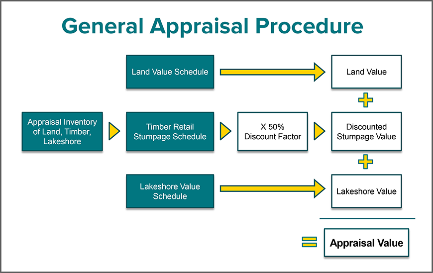
- Land Value Schedule is used to determine the Land Value.
- Appraisal inventory of Land, Timber and Lakeshore and the Timber Retail Stumpage Schedule, multiplied by a 50% discount, provide the discounted Stumpage Value.
- Lakeshore Value Schedule is used to determine the Lakeshore Value
Land Value + Discounted Stumpage Value + Lakeshore Value = Appraisal Value
2.7 Appraisal card example
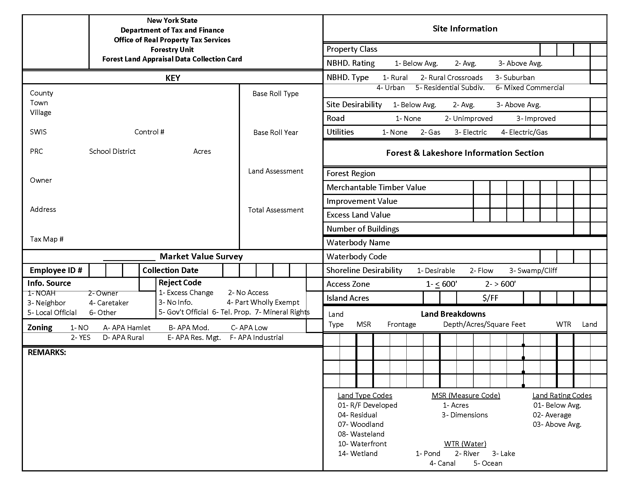
Forest Land Appraisal Data Collection Card–downloadable PDF
New York State Office of Real Property Services Forestry Unit Forest Land Appraisal Data Collection Card
Key
- County
- Town
- Village
- SWIS
- ERB
- Co
- Prc
- Sch dist
- LD SZ CD
- Owner
- Address
- Grid coordinates
- I.D. As shown on local assessment roll
- Market value survey
- Appraisal selection code
- Major type value interval
- Base roll type
- Base roll year
- Land assm't
- Total assm't
Employee I.D.
Collection date
Info. Source
- NOAH
- Owner
- Neighbor
- Tenant
- Local official
- Other
Reject code
- Excess change
- No access
- No information
- Part wholly exempt
- Govt official
- Tel. Property
- Mineral rights
Zoning
- No
- Yes
- APA Hamlet
- APA Mod
- APA Low
- APA Rural
- APA Res Mgt
- APA Industrial
Remarks
Handwritten notes: Run through quality control checklist before turning in cards
Site Information
Property class: Match key
NBHD.Rating (1 - below average; 2 - average; 3 - above average)
NBHD.Type (1 - rural; 2 - rural crossroads; 3 - suburban; 4 - urban; 5 - residential subdivision; 6- mixed commercial)
Site desirability (1 - below average; 2 - average; 3 - above average)
Road (1-none; 2-unimproved; 3-improved); “remote” written in.
Water (1-none; 2-private; 3-commercial/public)
Utilities (1-none; 2-gas; 3-electric; 4-electric/gas)
forest & lakeshore information section
land breakdowns
Section 3: Forestry—waterfront
Forest appraisers are expected to be able to calculate waterfront values for lakes and ponds. There are several sources of information available to assist the appraiser in this endeavor.
3.1 Information sources
Sales of waterfront are collected continuously. A file is kept, by county, of all collected waterfront sales. These sales are used as comparable sales for equalization rate samples and to state-owned land. Standard procedures for using comparable sales and adjustments must be observed.
Appraisal problems surface where there are no available comparable sales. In these cases, it is acceptable to refer to state-owned land value schedules. State-owned waterfront is valued by analyzing waterfront sales and producing a schedule of values encompassing comparable lakes and discount factors. The Forestry Unit has lists of lakes and ponds that are comparable, so sales on one water body can indicate a value for others. By referring to value schedules, you are guided by sales on comparable water bodies.
3.2 Valuation methodology
Waterfront is valued by the appraiser using the following methodology:
- The waterfront is visited, and the appropriate classification is applied (D1-F2).
- The front footage of each classification is determined using GIS mapping software.
- Sales on each water body are analyzed to indicate value. (note: An alternate method available to Forestry Unit appraisers when no comparable sales exist is the option of referring to predetermined schedules on taxable state-owned land water bodies).
- The value per front foot of a building lot sized parcel for each classification of state-owned land is looked up in the State-owned land waterfront file.
- The State-owned land base price per front foot is discounted for size by the appropriate factor from the discount chart.
Example: If a 2000' piece is being appraised on good lake and the State-owned land value is XXX for a building lot, then XXX times 31% times 2000 is the value of the waterfront portion of the appraisal.
- This calculated value can be further adjusted for lake quality.
Example: If best lake is used as a comparable to good lake, the State-owned land value of best lake might have to be adjusted to make it more closely match good lake.
3.3 Shore type definitions
D-1: Quality of shoreline and water is good to excellent; shoreline is within 600 feet of access road.
D-2: Quality of shoreline and water is good to excellent; shoreline is more than 600 feet from access road or is accessible by boat only.
F-1: Quality of shoreline and water is fair to poor; shoreline is within 600 feet of access road.
F-2: Quality of shoreline and water is fair to poor; shoreline is more than 600 feet from access road or is accessible by boat only.
Swamp/Cliff: This is recognized as the least valuable shoreline designation.
3.4 Criteria for determining if waterbodies are to receive a value
A good rule of thumb is that twenty-four points usually qualifies a water body to have a front-foot value. However, waterfront valuation experience and common sense judgments should be relied upon.
(surface area) x (distance) x (terrain) x (quality) x (depth) = 24 or more points
Surface area
- 1 = 1 to 10 acres
- 2 = 11 to 30 acres
- 3 = 31 to 100 acres
- 4 = over 100 acres
Distance from road
- 1 = over 3.1 miles
- 2 = 1.1 to 3.0 miles
- 3 = 0.6 to 1.0 miles
- 4 = 0 to 0.5 miles
Terrain
- 1 = steep, rugged
- 2 = moderate, hilly
- 3 = gently sloping
Shoreline quality
- 1 = poor (swampy, mucky (typical of Beaver Pond))
- 2 = fair (some wet areas, brushy, less desirable bottom (flow type))
- 3 = good (average or above average, generally dry, some gravel or sandy bottom)
- 4 = excellent (rocky or sandy shoreline, desirable waterfront)
Depth
- 1 = shallow 0 to 6' mean depth
- 2 = average 7' to 20'
- 3 = deep over 20' {from Adirondack Lake Survey Report or depth charts, if available)
3.5 Reductions for size of lake frontage
| Front feet | Percentage of base lot value |
Front feet | Percentage of base lot value |
|---|---|---|---|
| 0—199* | 50 | 397—408 | 57 |
| 100—199 | 115 | 409—425 | 56 |
| 110—199 | 112 | 426—441 | 55 |
| 120—199 | 109 | 442—458 | 54 |
| 130—199 | 106 | 459—475 | 53 |
| 140—199 | 103 | 476—491 | 52 |
| 150—199** | 100 | 492—508 | 51 |
| 200—199 | 83 | 509—525 | 50 |
| 205—199 | 82 | 526—541 | 49 |
| 213—199 | 81 | 542—556 | 48 |
| 222—199 | 80 | 557—569 | 47 |
| 230—199 | 79 | 570—579 | 46 |
| 237—199 | 78 | 580—594 | 45 |
| 247—199 | 77 | 595—624 | 44 |
| 254—199 | 76 | 625—674 | 43 |
| 261—199 | 75 | 675—724 | 42 |
| 268—199 | 74 | 725—774 | 41 |
| 275—199 | 73 | 775—849 | 40 |
| 282—199 | 72 | 850—924 | 39 |
| 290—199 | 71 | 925—974 | 38 |
| 297—199 | 70 | 975—1049 | 37 |
| 305—312 | 69 | 1050—1149 | 36 |
| 313—321 | 68 | 1150—1349 | 35 |
| 322—329 | 67 | 1350—1549 | 34 |
| 330—337 | 66 | 1550—1749 | 33*** |
| 338—346 | 65 | 1750—1849 | 32 |
| 347—353 | 64 | 1850—2049 | 31 |
| 354—360 | 63 | 2050—2449 | 30 |
| 361—367 | 62 | 2450—2649 | 29 |
| 368—374 | 61 | 2650—3249 | 28 |
| 375—382 | 60 | 3250—3649 | 27 |
| 383—389 | 59 | 3650—4249 | 26 |
| 390—396 | 58 | 4250+ | 25 |
|
|||
Section 4: Forestry—stumpage
4.1 Stumpage description
The contributory market value of timber stumpage value is determined using the principles that follow.
- A schedule of timber stumpage values shall be prepared which shall contain per acre prices representing the market value of timber stumpage. Stumpage values shall be distinguished for most existing combinations of the classifications of forest stands.
- The timber price data utilized to construct this schedule shall be obtained through personal interviews with logging contractors, sawmill operators, consulting foresters, and other people in the wood-using industry. Confirmed contract prices obtained from such interviews shall be the basis for stumpage schedule values.
- In calculating the contributory value of merchantable timber, all stumpage values shall be discounted by 50% to reflect the fact that timber stumpage contributes less than its market price per acre to the market value of forested land because of ownership risks, opportunity costs of waiting to harvest the entire parcel (large tracts), property taxes, and other such costs of landownership.
The following is an explanation of how stumpage values are calculated by ORPTS' Forestry Unit.
Stumpage is a term used to describe the value of standing timber or wood on the stump. It is important to realize that there are numerous costs associated with getting timber from the stump to the market. A skilled laborer cuts the tree; another skilled laborer in an $80,000 machine drags (skids) the log to a truck; another skilled laborer in a $30,000 machine loads the log onto a truck; a driver in a $100,000 truck hauls the log to the mill yard where it must be unloaded. All these costs, plus a profit margin must come out for a tree to pay its way to the sawmill. The farther the tree is located from the market, the more difficult it is to extrapolate a stumpage value.
The Forestry Unit uses three sources when determining its raw stumpage values. The first source is an extensive network of loggers and consulting foresters who buy standing timber and are willing to discuss these purchases with us. From them we obtain contract sales information, such as what species were bought, their quality, quantity and under what special conditions. These logging contractors also provide us with information on various logging costs for our analysis phase, as well as firsthand market data.
The second source for stumpage data comes from a semi-annual report published by the New York State Department of Environmental Conservation. The report is published for landowners and loggers who need to know a value range for forest products. Stumpage data is reported by geographic region and by forest product. It proves to be an excellent resource for stumpage value ranges.
The third source is readily available, but less reliable. Sawmills print lists of products needed and prices they are willing to pay, delivered to the mill. These prices, less logging costs, should, in theory, equate to stumpage prices. This theoretical method is acceptable appraisal procedure, but is used sparingly, because the fluctuating nature of logging costs makes this residual method less reliable than direct sales data.
These three sources of information are listed spreadsheet fashion on a regional chart. Stumpage values are selected manually from the most reliable of the available data. Median, mode, mean, weighted mean and professional judgment have all been used in the selection. Confidence in the data is the main criteria for placing the weight on certain base values.
Adjustments must be made to these base prices to accommodate different "logging chance" situations. Smaller logs are worth less as they take more processing. Logs far from the road are worth less as they must be skidded further. Logs on steep terrain are worth less as they are more difficult to harvest. Tracts with the best timber removed are worth less than other typical tracts.
It has been the policy to disregard any short term or sporadic changes in stumpage values. The goal is to reflect only long-range consistent trends. This trending process can be accomplished by fitting a curve to the adjusted base prices over time. In other words, adjusted base prices fitted to a time curve are called trended values and are used to smooth out market data and strengthen weak or nonexistent data. A steady and reliable flow of timber values representative of the market, but not unduly sensitive to its day-to-day changes, is the result of trending.
A test for reasonableness is required. Harmonization curve sets are constructed and used to fulfill this test. Harmonization curves are parallel species lines opposite the various conditions. When lines that should run parallel do not, an identifiable reason should exist or erroneous data should be suspected. An example of this relationship might aid in the explanation. Sugar maple sells for more than beech, in general. It brings more at the mill. On good sites, it is worth more. On steep terrain it is worth more. Near or far from the road, sugar maple is worth more. If you have a data point where beech appears to have a higher value than sugar maple, you have cause for concern about that data point. A graphic display helps illuminate this relationship. Any data that forces a harmonization curve to fall in an illogical fashion must be checked. After all the data is acceptable, it is presented in chart form.
A summary at this point is in order. Stumpage data is collected from dealers in the stumpage and log market. A single value is picked to represent a value per species for each region. These values are adjusted to find values under different logging conditions. Unusual or short-term market fluctuations are trended out. Illogical data is identified and often eliminated. The final set of material is presented in chart form as a Stumpage Report.
The heart of the Stumpage Report consists of these value charts, along with an explanation of the merchantability standards which apply to each species. A section on general observations is included to formally recognize conditions found in the field which might now, or in the future, influence stumpage prices.
Section 5: Forestry–timber inventory
5.1 Introduction
The multi-variate forest inventory system presently being used employs seven variables, each of which captures a particular characteristic of both land and timber and has a measurable effect on value.
5.2 Definition of inventory variables
Forest region: The seven forest regions recognized are delineated on the basis of differences in forest stand composition, timber merchantability standards, forest product markets, and forest product utilization (figure 4).
Forest type:
- Pure: A group of species or closely associated groups of species which comprise 75% or more of the gross cubic foot volume of a stand.
- Mixed: A stand composed of a mixture of two or more pure forest types wherein each type comprises between 25% and 75% of the gross cubic foot volume per acre of a stand.
Forest site: Site quality is a measure of the ability of a particular area to grow tree crops in a temporal reference. The shorter the time to maturity, the better the site quality is, dependent upon the interaction of edaphic, climatic, and biotic factors, and is measured by the height of dominant and co-dominant trees in a stand.
Gross Timber volume: Total wood volume (usually per acre) in all living trees including cull as measured by criteria below.
- Cubic foot: Wood volume, excluding bark, of all living trees, measured between a one foot stump height and a four inch top diameter.
- Cord: A cord is one standard measure of cubic foot volume. One cord equals a pile of wood four feet high, four feet wide, and eight feet long. Two common markets for cordwood are firewood and pulpwood for paper or chipboard manufacture.
- Board foot: Wood volume of all living trees, calculated by the International 1/4 inch Log Rule, between a one foot stump height and an eight inch top diameter for hardwood species and between a one foot stump height and a six inch top diameter for coniferous species.
- Basal area: Basal area (the area of a cross section of a tree) is measured in the field at DBH (diameter at breast height) and converted to board foot volume using standard volume charts.
Cut class: This variable measures the quality of a stand in terms of cull percentage and species desirability.
- Class 1: Typically this stand has not been commercially logged, has a relatively low cull percentage, and contains species in demand for a variety of forest products.
- Class 2: This stand has, probably, been logged, with the residual stand high in cull and undesirable or low demand species.
Accessibility:
- Class 1: Land and timber that lies within one-quarter mile of an all-weather, maintained road.
- Class 2: Land and timber that lies beyond one-quarter mile of an all-weather, maintained road.
Ease of logging: This variable is a measure of topography and terrain features.
- Class 1: Less than 20% slope and easy vehicle traverse.
- Class 2: 20% to 40% slope and difficult vehicle traverse.
- Class 3: Greater than 40% slope; impossible vehicle traverse, or stands with extremely poor site conditions, low timber volume, or other factors that make harvesting uneconomical.
5.3 Procedures for determination of timber volume per acre class
- Initial aerial photo interpretation
The parcel to be inventoried is plotted using GIS mapping software, parcel boundary shapefiles, and the most current orthoimage. Using the GIS map obvious non-productive sites, such as rock outcrops, alder beds, water, and so on, are delineated first. Homogeneous forest stands (in terms of forest type, tree crown size, cut class, accessibility, and topography) are outlined next. The subjects are also reviewed for the presence logging roads and recent harvest activity.
- Field reconnaissance
Each forest stand delineated on the parcel is a sampling unit. A minimum of 9 sample points is taken within each stand. Sample points are taken at random along a cruise line through the stand. At each point, using a 10-factor wedge prism, a tree count is tallied (on Plotless Cruising Tally Form) of qualifying trees by species. Basal area per acre is calculated by dividing total tree count by 9 and multiplying the result by 10. Basal area per acre is then converted to gross volume per acre by use of the conversion table.
If a stand is composed of a mixture of species groups (mixed type), the gross volume per acre is determined by applying the total basal area per acre to each species group on the conversion table and weighting the volumes in proportion to the basal area distribution of the sample species groups.
- Reliability of sample
In order to determine the reliability of the volume estimate for each stand, the sample data is tested in the following manner:
The gross volume per acre class is recorded for each sample point. The mean gross volume per acre class is calculated.
Example: Suppose you measured a total of 43 trees on 9 sample plots. 43/9 = 4.8 trees per plot. The standard 10 factor wedge prism indicates 4.8 x 10 = 48 square feet of basal area per acre. The standard deviation is calculated by dividing the range of the volume classes by 3; 1/3 = 0.33. The coefficient of variation is then calculated; 0.33/4.8 = 6.9%. The standard of error, expressed as a percent of the mean 6.9 divided by the square root of 9 which equals 2.3%.
Either of two methods is used to determine adequacy of sample:
- Method 1 is applied for any stand whose mean volume class is 1-4.
- Method 2 is applied for any stand whose mean volume class is 5-9.
Method 1: The standard deviation is divided by the square root of "n" (9 sample points) to arrive at the absolute standard error. If this figure is less than 0.4 of a gross volume per acre class, the 9 sample points are adequate (0.4 being the desired accuracy at the 68% level of probability). If the standard error exceeds 0.4, the total number of sample points needed is calculated by:
- SE = SD/N
- n = total number of samples
- SE = standard error
- SD = standard deviation
Method 2: The same formula applied in Method 1 is used here, except that standard deviation and standard error are expressed as percentages:
- CV = SD/n
- x = mean volume class
- n = total number of samples
- SE = 5% (desired accuracy at 68% probability)
- SE(%) = CV/n
- CV = coefficient of variation
- SD = standard deviation
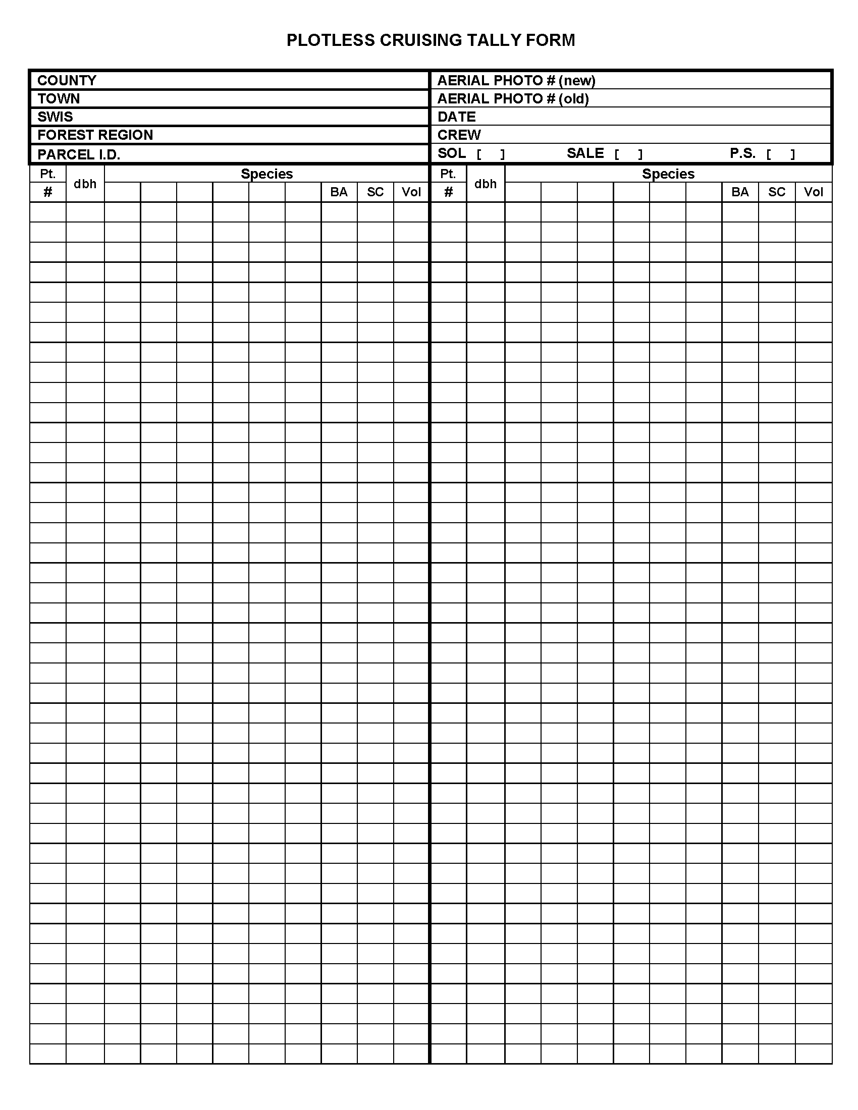
Plotless Cruising Tally Form–downloadable PDF
Fields in the Plotless Cruising Tally Form:
- County
- Town
- SWIS
- Forest Region
- PCL. I.D.
- Aerial Photo No. (old)
- Aerial Photo No. (new)
- Date
- Crew
- SOL (checkbox)
- Sale (checkbox)
- P.S. (checkbox)
These are followed by columns for listing
- Plot Numbers
- dbh
- Species
5.4 Basal area per acre tables
| Basal Area (sq ft)** |
Hard Maple, Yellow Birch, and Beech | Oak | Aspen | White Pine | Spruce-Fir | Hemlock | ||||||||||||||||||||||||||||||||||||||||||||||||||||||||||||||||||||||||||||||||||||
|---|---|---|---|---|---|---|---|---|---|---|---|---|---|---|---|---|---|---|---|---|---|---|---|---|---|---|---|---|---|---|---|---|---|---|---|---|---|---|---|---|---|---|---|---|---|---|---|---|---|---|---|---|---|---|---|---|---|---|---|---|---|---|---|---|---|---|---|---|---|---|---|---|---|---|---|---|---|---|---|---|---|---|---|---|---|---|---|---|---|---|
| Uncut | Cut | |||||||||||||||||||||||||||||||||||||||||||||||||||||||||||||||||||||||||||||||||||||||||
| Site 1 | Site 2 | Site 3 | Site 1 | Site 2 | Site 2 | Site 3 | Site 1 | Site 2 | Site 3 | Site 1 | Site 2 | Site 3 | Site 1 | Site 2 | Site 3 | Site 1 | Site 2 | |||||||||||||||||||||||||||||||||||||||||||||||||||||||||||||||||||||||||
| 0 | 0 | 0 | 0 | 0 | 0 | 0 | 0 | 0 | 0 | 0 | 0 | 0 | 0 | 0 | 0 | 0 | 0 | 0 | ||||||||||||||||||||||||||||||||||||||||||||||||||||||||||||||||||||||||
| 1 | 0.1 | 0.1 | 0.1 | 0.1 | 0.1 | 0.1 | 0.1 | 0.1 | 0.1 | 0.1 | 0.1 | 0.1 | 0.1 | 0.1 | 0.1 | 0.1 | 0.1 | 0.1 | ||||||||||||||||||||||||||||||||||||||||||||||||||||||||||||||||||||||||
| 2 | 0.3 | 0.2 | 0.2 | 0.3 | 0.2 | 0.2 | 0.2 | 0.3 | 0.2 | 0.2 | 0.2 | 0.2 | 0.1 | 0.2 | 0.2 | 0.1 | 0.2 | 0.1 | ||||||||||||||||||||||||||||||||||||||||||||||||||||||||||||||||||||||||
| 3 | 0.4 | 0.3 | 0.2 | 0.4 | 0.4 | 0.4 | 0.2 | 0.4 | 0.4 | 0.2 | 0.4 | 0.3 | 0.2 | 0.4 | 0.3 | 0.2 | 0.2 | 0.2 | ||||||||||||||||||||||||||||||||||||||||||||||||||||||||||||||||||||||||
| 4 | 0.6 | 0.4 | 0.3 | 0.6 | 0.5 | 0.5 | 0.3 | 0.6 | 0.5 | 0.3 | 0.5 | 0.4 | 0.2 | 0.5 | 0.4 | 0.2 | 0.3 | 0.2 | ||||||||||||||||||||||||||||||||||||||||||||||||||||||||||||||||||||||||
| 5 | 0.7 | 0.5 | 0.4 | 0.7 | 0.6 | 0.6 | 0.4 | 0.7 | 0.6 | 0.4 | 0.6 | 0.5 | 0.3 | 0.6 | 0.5 | 0.3 | 0.4 | 0.3 | ||||||||||||||||||||||||||||||||||||||||||||||||||||||||||||||||||||||||
| 10 | 1.3 | 1.1 | 0.8 | 1.4 | 1.3 | 1.2 | 0.8 | 1.5 | 1.2 | 0.8 | 1.1 | 1.0 | 0.6 | 1.1 | 0.9 | 0.6 | 0.8 | 0.6 | ||||||||||||||||||||||||||||||||||||||||||||||||||||||||||||||||||||||||
| 15 | 2.0 | 1.6 | 1.2 | 2.1 | 2.0 | 1.8 | 1.2 | 2.3 | 1.8 | 1.2 | 1.6 | 1.5 | 0.9 | 1.6 | 1.4 | 0.9 | 1.2 | 1.0 | ||||||||||||||||||||||||||||||||||||||||||||||||||||||||||||||||||||||||
| 20 | 2.7 | 2.2 | 1.6 | 2.8 | 2.7 | 2.4 | 1.6 | 3.1 | 2.5 | 1.6 | 2.1 | 2.0 | 1.3 | 2.2 | 1.9 | 1.3 | 1.6 | 1.4 | ||||||||||||||||||||||||||||||||||||||||||||||||||||||||||||||||||||||||
| 25 | 3.4 | 2.8 | 2.6 | 3.6 | 3.4 | 3.1 | 2.1 | 3.9 | 3.3 | 2.1 | 2.7 | 2.6 | 1.7 | 2.8 | 2.4 | 1.7 | 2.0 | 1.8 | ||||||||||||||||||||||||||||||||||||||||||||||||||||||||||||||||||||||||
| 30 | 4.2 | 3.4 | 3.2 | 4.3 | 4.0 | 3.9 | 2.6 | 4.8 | 4.0 | 2.6 | 3.3 | 3.2 | 2.1 | 3.4 | 2.9 | 2.1 | 2.4 | 2.2 | ||||||||||||||||||||||||||||||||||||||||||||||||||||||||||||||||||||||||
| 35 | 5.0 | 4.0 | 3.8 | 5.1 | 4.7 | 4.6 | 3.2 | 5.6 | 4.8 | 3.2 | 3.9 | 3.8 | 2.5 | 4.0 | 3.4 | 2.5 | 2.8 | 2.6 | ||||||||||||||||||||||||||||||||||||||||||||||||||||||||||||||||||||||||
| 40 | 5.8 | 4.6 | 4.4 | 5.9 | 5.4 | 5.4 | 3.8 | 6.5 | 5.6 | 3.8 | 4.6 | 4.4 | 3.0 | 4.7 | 4.0 | 3.0 | 3.3 | 3.0 | ||||||||||||||||||||||||||||||||||||||||||||||||||||||||||||||||||||||||
| 45 | 6.6 | 5.3 | 5.0 | 6.8 | 6.1 | 6.2 | 4.4 | 7.3 | 6.5 | 4.4 | 5.3 | 5.0 | 3.5 | 5.4 | 4.6 | 3.5 | 3.8 | 3.5 | ||||||||||||||||||||||||||||||||||||||||||||||||||||||||||||||||||||||||
| 50 | 7.5 | 6.0 | 5.7 | 7.7 | 6.8 | 7.0 | 5.0 | 8.2 | 7.4 | 5.0 | 6.0 | 5.7 | 4.0 | 6.1 | 5.2 | 4.0 | 4.4 | 4.0 | ||||||||||||||||||||||||||||||||||||||||||||||||||||||||||||||||||||||||
| 55 | 8.4 | 6.7 | 6.4 | 8.6 | 7.5 | 7.9 | 5.7 | 9.1 | 5.7 | 6.8 | 6.4 | 4.5 | 6.8 | 5.8 | 4.5 | 5.0 | 4.5 | |||||||||||||||||||||||||||||||||||||||||||||||||||||||||||||||||||||||||
| 60 | 9.3 | 7.4 | 7.1 | 9.5 | 8.2 | 8.7 | 6.4 | 10.0 | 6.4 | 7.6 | 7.1 | 5.1 | 7.5 | 6.5 | 5.1 | 5.6 | 5.1 | |||||||||||||||||||||||||||||||||||||||||||||||||||||||||||||||||||||||||
| 65 | 10.2 | 8.2 | 7.9 | 10.4 | 8.8 | 9.7 | 7.1 | 10.9 | 7.1 | 8.4 | 7.8 | 5.7 | 8.3 | 7.2 | 5.7 | 6.2 | 5.6 | |||||||||||||||||||||||||||||||||||||||||||||||||||||||||||||||||||||||||
| 70 | 11.1 | 8.9 | 8.7 | 11.3 | 9.5 | 10.7 | 7.9 | 11.8 | 7.9 | 9.2 | 8.5 | 6.3 | 9.1 | 7.9 | 6.3 | 6.8 | 6.2 | |||||||||||||||||||||||||||||||||||||||||||||||||||||||||||||||||||||||||
| 75 | 12.1 | 9.7 | 9.5 | 12.2 | 10.2 | 11.7 | 8.7 | 12.7 | 8.7 | 10.0 | 9.2 | 6.9 | 9.9 | 8.6 | 6.9 | 7.5 | 6.8 | |||||||||||||||||||||||||||||||||||||||||||||||||||||||||||||||||||||||||
| 80 | 13.1 | 10.5 | 13.1 | 10.9 | 12.7 | 9.5 | 13.6 | 9.5 | 10.8 | 10.0 | 7.5 | 10.8 | 9.4 | 7.5 | 8.2 | 7.5 | ||||||||||||||||||||||||||||||||||||||||||||||||||||||||||||||||||||||||||
| 85 | 14.1 | 11.3 | 14.0 | 11.6 | 14.5 | 11.7 | 10.8 | 8.1 | 11.7 | 10.2 | 8.1 | 8.9 | 8.1 | |||||||||||||||||||||||||||||||||||||||||||||||||||||||||||||||||||||||||||||
| 90 | 15.2 | 12.2 | 14.9 | 12.3 | 15.4 | 12.7 | 11.6 | 8.8 | 12.6 | 11.0 | 8.8 | 9.6 | 8.8 | |||||||||||||||||||||||||||||||||||||||||||||||||||||||||||||||||||||||||||||
| 95 | 16.3 | 13.0 | 15.9 | 13.0 | 16.3 | 13.7 | 12.4 | 9.5 | 13.5 | 11.9 | 9.5 | 10.4 | 9.5 | |||||||||||||||||||||||||||||||||||||||||||||||||||||||||||||||||||||||||||||
| 100 | 17.4 | 13.9 | 16.9 | 17.3 | 14.7 | 13.2 | 10.2 | 14.4 | 12.8 | 10.2 | 11.2 | 10.2 | ||||||||||||||||||||||||||||||||||||||||||||||||||||||||||||||||||||||||||||||
| 105 | 18.5 | 14.8 | 17.9 | 15.7 | 14.1 | 10.9 | 15.3 | 13.7 | 10.9 | 12.1 | 10.9 | |||||||||||||||||||||||||||||||||||||||||||||||||||||||||||||||||||||||||||||||
| 110 | 19.6 | 15.8 | 18.9 | 16.7 | 15.0 | 11.6 | 16.3 | 14.6 | 11.6 | 13.0 | 11.7 | |||||||||||||||||||||||||||||||||||||||||||||||||||||||||||||||||||||||||||||||
| 115 | 20.7 | 16.7 | 17.7 | 15.9 | 12.3 | 17.3 | 15.5 | 12.4 | 13.9 | 12.5 | ||||||||||||||||||||||||||||||||||||||||||||||||||||||||||||||||||||||||||||||||
| 120 | 21.8 | 17.7 | 18.8 | 16.8 | 18.3 | 16.4 | 13.2 | 14.8 | 13.3 | |||||||||||||||||||||||||||||||||||||||||||||||||||||||||||||||||||||||||||||||||
| 125 | 22.9 | 18.7 | 19.9 | 17.7 | 19.3 | 17.3 | 14.0 | 15.8 | 14.1 | |||||||||||||||||||||||||||||||||||||||||||||||||||||||||||||||||||||||||||||||||
| 130 | 24.0 | 19.7 | 21.0 | 18.6 | 20.3 | 18.2 | 14.9 | 16.8 | 15.0 | |||||||||||||||||||||||||||||||||||||||||||||||||||||||||||||||||||||||||||||||||
| 135 | 25.1 | 20.7 | 22.2 | 19.6 | 21.3 | 19.1 | 15.8 | 17.8 | 15.9 | |||||||||||||||||||||||||||||||||||||||||||||||||||||||||||||||||||||||||||||||||
| 140 | 26.2 | 23.4 | 20.6 | 22.3 | 20.0 | 16.9 | 18.8 | 16.8 | ||||||||||||||||||||||||||||||||||||||||||||||||||||||||||||||||||||||||||||||||||
| 145 | 24.6 | 21.6 | 23.4 | 21.0 | 17.8 | 19.9 | 17.7 | |||||||||||||||||||||||||||||||||||||||||||||||||||||||||||||||||||||||||||||||||||
| 150 | 25.8 | 22.6 | 24.5 | 22.0 | 21.0 | 18.6 | ||||||||||||||||||||||||||||||||||||||||||||||||||||||||||||||||||||||||||||||||||||
| 155 | 27.0 | 23.6 | 25.6 | 23.0 | 22.2 | 19.5 | ||||||||||||||||||||||||||||||||||||||||||||||||||||||||||||||||||||||||||||||||||||
| 160 | 28.2 | 24.6 | 26.8 | 24.0 | 23.4 | 20.4 | ||||||||||||||||||||||||||||||||||||||||||||||||||||||||||||||||||||||||||||||||||||
| 165 | 29.4 | 25.6 | 28.0 | 25.0 | 24.6 | 21.4 | ||||||||||||||||||||||||||||||||||||||||||||||||||||||||||||||||||||||||||||||||||||
| 170 | 30.6 | 26.6 | 29.3 | 26.0 | 25.8 | 22.4 | ||||||||||||||||||||||||||||||||||||||||||||||||||||||||||||||||||||||||||||||||||||
| 175 | 31.8 | 27.6 | 30.7 | 27.0 | 27.0 | 23.4 | ||||||||||||||||||||||||||||||||||||||||||||||||||||||||||||||||||||||||||||||||||||
| 180 | 33.0 | 28.6 | 32.2 | 28.0 | 28.2 | 24.4 | ||||||||||||||||||||||||||||||||||||||||||||||||||||||||||||||||||||||||||||||||||||
| 185 | 34.3 | 28.6 | 33.8 | 29.0 | 29.4 | 25.4 | ||||||||||||||||||||||||||||||||||||||||||||||||||||||||||||||||||||||||||||||||||||
| 190 | 35.6 | 30.7 | 35.5 | 30.0 | 30.8 | 26.4 | ||||||||||||||||||||||||||||||||||||||||||||||||||||||||||||||||||||||||||||||||||||
| 195 | 36.9 | 31.8 | 37.3 | 31.0 | 32.2 | 27.5 | ||||||||||||||||||||||||||||||||||||||||||||||||||||||||||||||||||||||||||||||||||||
| 200 | 38.2 | 32.9 | 39.2 | 32.0 | 33.6 | 28.6 | ||||||||||||||||||||||||||||||||||||||||||||||||||||||||||||||||||||||||||||||||||||
|
*by Forest Types and Forest Sites (Hardwood trees 11.6" + DBH (ob), Softwood trees 8.6" + DBH (ob)) |
||||||||||||||||||||||||||||||||||||||||||||||||||||||||||||||||||||||||||||||||||||||||||
|
|
|||||||||||||||||||||||||||||||||||||||||||||||||||||||||||||||||||||||||||||||||||||||||
5.5 Map of New York State forest regions
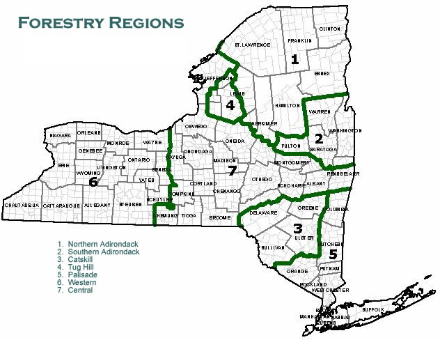
New York State Forest Regions
- Region 1: Clinton, Essex, Franklin, Hamilton, Herkimer (partial), Lewis (partial), Oneida (partial) and St. Lawrence Counties
- Region 2: Fulton, Rensselaer (partial), Saratoga, Schenectady (partial), Warren and Washington Counties
- Region 3: Delaware (partial), Greene, Sullivan and Ulster Counties
- Region 4: Jefferson (partial), Lewis (partial) and Oswego (partial) Counties
- Region 5: Bronx, Columbia, Dutchess, Kings, Nassau, New York, Orange, Putnam, Queens, Richmond, Rockland, Suffolk and Westchester Counties
- Region 6: Allegany, Cattaraugus, Chautauqua, Erie, Genesee, Livingston, Monroe, Niagara, Ontario, Orleans, Schuyler, Seneca, Steuben, Wayne, Wyoming and Yates Counties
- Region 7: Albany, Broome, Cayuga, Chemung, Chenango, Cortland, Delaware (partial), Herkimer (partial), Jefferson (partial), Madison, Montgomery, Oneida (partial), Onondaga, Otsego, Oswego (partial), Rensselaer *(partial), Schenectady (partial), Schoharie, Tioga and Tompkins Counties
5.6 Mensuration standards
Tree diameter
Tree diameter: The point of sampling procedure utilized in obtaining an estimate of timber volume per acre necessitates a tally of individual trees according to diameter. The following table lists the diameter standards used.
| Size class | Hardwood species | Coniferous species |
|---|---|---|
| Seedling or sapling | < 5.6 | < 5.6 |
| Pole timber | 5.6 to 11.5 | 5.6 to 8.5 |
| Saw timber | > 11.5 | > 8.5 |
| *dbh = diameter at breast height; this is a standard tree measurement for standing timber | ||
Site class
Site class is determined based on tree height. Since trees grow at different rates in natural stands vs reforestation stands (plantings) different standards are used to determine site class. The following tables show site class based height in 16ft logs for natural stands and internodal growth in feet for reforestation stands.
Site class:
- forest site
- natural stands
Natural stands
| Numeric code | Hardwood species | Coniferous species |
|---|---|---|
| 01 | ≥ 3 | ≥ 5 |
| 02 | 2 to < 3 | 3 to < 5 |
| 03 and 04 | < 2 | < 3 |
| * In dominant and co-dominant trees. | ||
Reforestation stands
| Numeric code | Red, White, Scotch, Jack Pine, Norway Spruce | White Spruce | Larch |
|---|---|---|---|
| 01 | < 9.0 | < 8.0 | < 12.0 |
| 02 | 7.0 to 8.9 | 6.0 to 7.9 | 9.0 to 11.9 |
| 03 | < 7.0 | < 6.0 | < 9.0 |
| *Beginning at first whorl above dbh | |||
5.7 Non-forest site classes
| Numeric code | Description |
|---|---|
| 05 | Permanent alder beds |
| 06 | Permanent brush, muskeg, and so on |
| 07 | Beaver grass, grassy swamps |
| 08 | Rock outcrop |
| 09 | Agricultural land in use |
| 10 | Idle agricultural land |
| 11 | Water |
| 12 | Land inventoried for waterfront value (200’ in depth) |
| 13 | Land inventoried as a home site |
| 14 | Land inventoried for road front value (200’ in depth) |
| 15 | Land inventoried as cabin site (hunting camp, and so on) |
| 16 | Miscellaneous (power lines, gas lines, roads, and so on) |
5.8 Standard types
| Numeric code | Forest type | Species composition |
|---|---|---|
| 01 | Northern hardwood | Hard maple, beech, yellow birch, red maple, black cherry, white ash, and basswood |
|
02 |
Northern hardwood—white pine |
Northern hardwood species and white pine |
|
03 |
Northern hardwood–hemlock |
Northern hardwood species and hemlock |
|
04 |
Northern hardwood—spruce-fir |
Northern hardwood species, red spruce and balsam fir |
|
05 |
Pioneer hardwood |
Aspen, gray birch, birch, red maple |
|
06 |
Gray birch |
Gray birch |
|
07 |
Swamp hardwood |
Black ash, red maple, elm (Site 4 only) |
|
08 |
Paper birch |
Paper birch |
|
10 |
Oak |
Any oak species |
|
13 |
Oak—pine |
Any oak species and pine species |
|
20 |
White pine |
White pine |
|
23 |
Spruce-fir |
Red spruce, white spruce, balsam fir |
|
24 |
White pine—hemlock |
White pine and hemlock |
|
25 |
Hemlock |
Eastern hemlock |
|
26 |
Tamarack—cedar |
Tamarack and white cedar (Site 4 only) |
|
28 |
Black spruce |
Black Spruce (Site 4 only) |
|
29 |
Red pine |
Red pine |
|
30 |
Pitch pine |
Pitch pine |
|
31 |
Jack pine |
Jack pine |
|
32 |
Red pine—white pine |
Red and white pine |
|
33 |
Cedar swamp |
White cedar (Site 4 only) |
|
34 |
White pine—spruce |
White pine, red spruce, balsam fir |
|
Numeric code |
Forest type and species composition |
|---|---|
|
40 |
White pine |
|
41 |
Red pine |
|
42 |
Scotch pine |
|
43 |
Larch |
|
44 |
Norway spruce |
|
45 |
White spruce |
|
46 |
Jack pine |
|
47 |
Pitch pine |
|
48 |
Douglas fir |
|
50 |
White pine and red pine |
|
51 |
White pine and Norway spruce |
|
52 |
Larch and spruce |
|
53 |
Scotch pine and white pine |
|
54 |
Red pine and Norway spruce |
|
55 |
Scotch pine and red pine |
|
56 |
Mixed plantation & natural species (Volume Class 1 only) |
|
57 |
Volume class 1 plantation of unknown species |
5.9 Timber volume per acre class
|
Numeric code |
Gross volume per acre |
Stand description |
|---|---|---|
|
1 |
0—399 cubic feet |
Seedling or sapling |
|
2 |
400—799 cubic feet |
Light poles |
|
3 |
800 cubic feet—1999 board feet |
Heavy poles |
|
4 |
2000—4999 board feet |
Light sawtimber |
|
5 |
5000—9999 board feet |
Medium sawtimber |
|
6 |
10,000—14,999 board feet |
Heavy sawtimber |
|
7 |
15,000—19,999 board feet |
Very heavy sawtimber |
|
8 |
20,000—24,999 board feet |
Very heavy sawtimber |
|
9 |
25,000+ board feet |
Very heavy sawtimber |
|
Numeric code |
Degree of slope in % |
Physical features |
|---|---|---|
|
1 |
<20 |
Easy vehicle traverse |
|
2 |
21 to 40 |
Difficult vehicle traverse |
|
3 |
>40 |
Poor-growing site, low-timber volume, impossible vehicle traverse |
5.10 Taxable state-owned lands
Background
In the State of New York, Sections 530 through 538 of Title 2 of the Real Property Tax Law prescribe the power and the extent of the non sovereign, subordinate local units to tax state-owned lands. Several other sections of Title 2 specify how the taxation and assessment of state-owned lands is to be approached. In that regard, Subdivision 1 of Section 542 is of particular interest for it states in part: "state-owned lands subject to taxation shall be valued as if privately owned and assessed at the same percentage of full value as other taxable real property in the assessing unit…".
In New York, the law requires the real property tax to be levied on an ad valorem basis with valuations being based on fair market value. Court decisions have equated fair market value (usually taken as actual market value) with full market value.
Value determinants
The market approach to valuation is employed by ORPTS in estimating the full market value of taxable lands. In appraising these lands, the values recognized have essentially been in three areas: bare land, merchantable timber, and waterfront values. The methodology utilized to determine these values is as follows.
- Bare land values: The ORPTS definition of bare land applies the term to land committed to vegetative growth but bearing no merchantable (marketable) standing timber as of the moment. Market value schedules for bare land are calculated for each assessing unit by examining private land sales. These schedules include two value considerations: 1) Value per acre for land accessible by road and 2) Value per acre for land without access by road (landlocked).
- Timber stumpage values: Stumpage values per acre are calculated for each of six market regions in the State. Within each region, average values per acre are produced for some 1000 different forest condition classes. These classes are derived from combinations of various levels of seven different variables. These variables are found to have a significant influence on values of stumpage. Altogether, 53 levels of the seven variables are recognized and considering all possible combinations, this allows for approximately 10,000 classifications. Stumpage prices are obtained through personal interviews with jobbers and contractors in the wood-using industry. Confirmed contract prices are utilized in calculating per acre values for various combinations of prospective timber products and standing timber characteristics.
- Waterfront values: Land lying within 200 feet of the shore of a lake or pond has been determined (from sales analysis) to have as its highest and best use as recreational potential. Private sales are examined and values calculated for three distinct classes of shoreline (based on suitability for recreational purposes) on each waterbody where a reliable number of sales exists. A comparable waterbody analysis determines which private waterbody will be used as the value determinant for each of the state-owned waterbodies or portions thereof.
State land inventory
A comprehensive and detailed inventory of all taxable state-owned lands was completed in 1994. Utilizing an unbiased, scientific sampling approach, land, timber and waterfront were classified both in terms of quality and quantity according to the variables previously mentioned. Up-to-date techniques of measurement were used and steps were taken to ensure sampling accuracy.
Valuation procedures
Final taxable state-owned land values are determined by matching the master inventory of state-owned lands with the appropriate land, timber, and waterfront value schedules and performing the necessary computations. This market value is subsequently reviewed for accuracy and reliability and approved by ORPTS for use in the screening of locally derived assessments.
| Tax law number | Description | Taxable for |
|---|---|---|
| Real Property Tax Laws | ||
| 532A | Forest Preserve lands | All purposes |
| 532B | Forest lands in towns of Altona & Dannemora, Clinton County—excluding institutional lands in Dannemora | All purposes |
| 532C | Allegany State Park | All purposes |
| 532D | Forest lands in Rockland Co. | All purposes |
| 532E | Palisade State Park | All purposes |
| 532F | Railroad from Lake Champlain to Clinton Prison | All purposes |
| 532G | Lands in 24 special towns: Otselic, Pharsalia, Sherburne, etc. | All purposes |
| 532H | Bashakill Wetlands; Town of Mamakating, Sullivan County | All purposes |
| 532I | Neversink Gorge; Towns of Forestburgh, Thompson, Mamakating, Sullivan County | All purposes |
| 532J | All lands owned by the state pursuant to subdivision two of section two hundred eight of the racing, pari-mutuel wagering and breeding law located within the counties of Nassau, Queens and Saratoga, inclusive of the improvements erected thereon. | All purposes and Special Assessments |
| 532K | Bowman Lake State Park, McDonough & Preston, Chenango Co | All purposes |
| 534 | Reforestation areas | All but county purposes |
| 536A | Lands in 38 special school districts | School purposes only |
| 536B | Lands in 19 special towns | School purposes only |
| 536C | Lands in certain special school districts and towns | School purposes only |
| 536D | Letchworth Park, Town of Genesee Falls, Wyoming Co | School purposes only |
| 536E | Central Pine Barrens, 5 special school districts, Suffolk Co | School purposes only, not forestry |
| 536F | Outside Central Pine Barren, Riverhead School District, | School purposes only, not forestry |
| 536G | Smithtown and Three Village CSD's, Suffolk Co | School purposes only, not forestry |
| Conservation Law | ||
| 587 (448) | Water regulating district lands | All purposes |
| ECL 15-2115 | Hudson/Black River Water regulating district lands | All purposes |
Appendix A: Deed descriptions
Warranty deed covenants as follows:
That the party of the second part shall quietly enjoy [emphasis added] the said premises [. . .].
That said—will forever warrant [emphasis added] the title to such premises. [Real Property Law Article 8 § 258]
Warranty deed (with lien covenants) covenants as follows:
First. That the party of the second part shall quietly enjoy [emphasis added] the said premises;
Second. That said … will forever warrant the title to said premises;
Third. That in compliance with Sec. 13 of the Lien Law [emphasis added], the grantor will receive the consideration of this conveyance and will hold the right to receive such consideration as a trust fund to be applied first for the purpose of paying the cost of the improvement and will apply the same first to the payment of the cost of the improvement before using any part of the total of the same of any other purpose. [Real Property Law Article 8 § 258]
Warranty deed (with full covenants) covenants as follows:
First. That said … is seized of said premises in fee simple [emphasis added], and has good right to convey the same;
Second. That the party of the second part shall quietly enjoy [emphasis added] the said premises;
Third. That the said premises are free from encumbrances [emphasis added];
Fourth. That the party of the first part will execute or procure any further necessary assurance of the title [emphasis added] to said premises;
Fifth. That said … will forever warrant [emphasis added] the title to said premises. [Real Property Law Article 8 § 258]
Bargain and sale deed (without covenant) states as follows:
Does hereby grant and release unto the party of the second part, […]
To have and to hold [emphasis added] the above granted premises unto the party of the second part, … and assigns forever [emphasis added]. [Real Property Law Article 8 § 258]
Forestry, section APP-A
Bargain and sale deed (with covenant) states as follows:
Does hereby grant and release [emphasis added] unto the party of the second part, [. . .]
To have and to hold [emphasis added] the above granted premises unto the party of the second part, . . . and assigns forever [emphasis added]. [Real Property Law Article 8 § 258]. [Real Property Law Article 8 § 258]
Quitclaim deed states as follows:
Does hereby promise, release, and quitclaim [emphasis added] unto the party of the second part, … and assigns forever, all (description) together with the appurtenances and all the estate and rights of the party of the first part in and to said premises.
To have and to hold [emphasis added] the premises granted unto the party of the second part, … and assigns forever. [Real Property Law Article 8 § 258]
Appendix B: Sale reject codes
Excess Change: This code indicates that construction and/or demolition of improvements have taken place after the sale and these changes cannot be adequately shown in the inventory. This code can also be used in the case of a major change in use of the property since the sale date.
No Access: This code shows that access to the property is necessary in order to collect and verify data for the sale and such access cannot be obtained.
No Information: Certain information is necessary to collect and verify sales data and cannot be obtained.
Not Arm's Length: This code indicates that the sale should not be considered valid for one of the following reasons (which should be recorded in the remarks section):
- One or both parties involved in the sale were not fully aware of the present or potential purposes for which the property could be used.
- One or both parties in the sale were acting under duress or coercion.
- The sale involved related individuals or corporations.
- The sale was a result of a liquidation of assets, a mortgage foreclosure, tax sale or quit claim.
- The sale involved a land contract (a contract given to a purchaser of real property who pays a portion of the purchase price when the contract is signed, and agrees to pay additional sums, at intervals, in the amount specified in the contract until the total purchase price is paid and the seller gives the deed).
- The sale included an excessive amount of personal property.
- The grantee or grantor is a lending institution or government agency.
- The deed is inadequate.
Improved Sale: This indicates that the sale would not be useful in sales analysis because improvements make a major contribution to the total value of the property.
Misclassified: This code indicates that the sale was misclassified on the sales label and is not a property class useful in sales analysis.
Not Representative: The sale is not representative of the usual transaction in the area (includes incorrect acreage on pre-printed label).
Not Needed Sample size is adequate without the collection of this sale (includes repeat sales from previous surveys).
Appendix C: Water body codes
Note: Click or tap the relevant column header to sort the lake codes table numerically by lake code, or alphabetically by lake name.
|
Lake code |
SWIS code |
Lake name |
|---|---|---|
|
0001 |
012000 |
Warner (or Warners) Lake |
|
0011 |
091300 |
Lake Champlain, section 1 |
|
0011 |
094000 |
Lake Champlain, section 1 |
|
0012 |
094000 |
Lake Champlain, section 2 |
|
0012 |
094200 |
Lake Champlain, section 2 |
|
0013 |
152089 |
Lake Champlain, section 3 |
|
0013 |
152200 |
Lake Champlain, section 3 |
|
0013 |
155000 |
Lake Champlain, section 3 |
|
0013 |
532400 |
Lake Champlain, section 3 |
|
0013 |
534600 |
Lake Champlain, section 3 |
|
0013 |
535201 |
Lake Champlain, section 3 |
|
0020 |
093600 |
Chateaugay Lake Narrows |
|
0020 |
162400 |
Chateaugay Lake Narrows |
|
0040 |
093489 |
Chateaugay Lake Upper |
|
0060 |
093489 |
Chazy Lake |
|
0080 |
092600 |
Cranberry Pond |
|
0090 |
094000 |
Davis Lake |
|
0100 |
092600 |
Fern Lake |
|
0120 |
092600 |
Newberry Pond |
|
0130 |
092000 |
Miner Lake |
|
0140 |
092600 |
Mud Pond (E of Silver Lake) |
|
0150 |
092600 |
Mud Pond (borders town of Franklin) |
|
0160 |
092600 |
Mud Pond (N/S Ore Bed Rd) |
|
0180 |
092600 |
Ore Pond |
|
0181 |
092889 |
Great Chazy River |
|
0190 |
093600 |
Lake Roxanne |
|
0200 |
092600 |
Silver Lake |
|
0220 |
092600 |
Taylor Pond |
|
0230 |
092200 |
Twin Pond |
|
0240 |
022089 |
Foster Lake |
|
0250 |
022800 |
Amity Lake |
|
0260 |
024200 |
Rushford Lake |
|
0260 |
026400 |
Rushford Lake |
|
0270 |
153400 |
Clear Pond |
|
0270 |
522400 |
Clear Pond |
|
0280 |
153400 |
Moxham Pond |
|
0301 |
042600 |
Quaker Lake—South Shore |
|
0302 |
042600 |
Quaker Lake—North Shore |
|
0310 |
047800 |
Red House Lake |
|
0320 |
045800 |
Lime Lake |
|
0330 |
046400 |
Linlyco Lake |
|
0335 |
052600 |
Duck Lake |
|
0340 |
122400 |
Huggins Lake |
|
0345 |
124000 |
Lake Chandakin |
|
0348 |
124000 |
Lake Lafever |
|
0350 |
122089 |
Little Pond |
|
0360 |
122400 |
Mud Pond |
|
0370 |
122400 |
Trout Pond or Cables Lake |
|
0380 |
122200 |
Silver Lake |
|
0390 |
123600 |
Delaware Lake (also known as Perch Pond) |
|
0400 |
124200 |
East Masonville Pond |
|
0410 |
154600 |
Alder Pond |
|
0420 |
153800 |
Arbutus Pond |
|
0430 |
152089 |
Augur Lake |
|
0440 |
153000 |
Ausable Lake—Lower |
|
0450 |
153000 |
Ausable Lake—Upper |
|
0455 |
153800 |
Baker's Pond |
|
0460 |
152400 |
Bouquet River |
|
0465 |
153800 |
Bradley Pond |
|
0470 |
154089 |
Averyville Pond (also known as Alford Pond) |
|
0480 |
153400 |
Balfour Lake |
|
0490 |
153689 |
Bartlett Pond |
|
0491 |
153689 |
Tub Mill Pond |
|
0500 |
153400 |
Beaver Ponds (2) |
|
0510 |
154600 |
Big Rogers Pond |
|
0520 |
154089 |
Big Cherrypatch Pond |
|
0530 |
154600 |
Bigsby Pond |
|
0540 |
154200 |
Boreas Ponds (also known as First Pond) |
|
0550 |
154200 |
Branch River Pond (also known as Palmer Pond) |
|
0560 |
154600 |
Bullet Pond |
|
0570 |
152089 |
Butternut Pond |
|
0571 |
152089 |
Hadley Pond |
|
0575 |
152089 |
Trout Pond |
|
0576 |
152089 |
Clark Pond |
|
0580 |
154089 |
Cameras Pond |
|
0590 |
153000 |
Cascade Lakes (Upper and Lower) |
|
0590 |
154089 |
Cascade Lakes (Upper and Lower) |
|
0600 |
153800 |
Catlin Lake |
|
0600 |
203200 |
Catlin Lake |
|
0610 |
153400 |
Chain Lakes (seven lakes) |
|
0620 |
153000 |
Chapel Pond |
|
0630 |
153400 |
Cheney Pond |
|
0635 |
153400 |
Corner Pond |
|
0635 |
153800 |
Corner Pond |
|
0640 |
153000 |
Round Pond |
|
0650 |
154200 |
Clear Pond |
|
0651 |
154200 |
Proctor Pond |
|
0652 |
154200 |
Challis Pond |
|
0655 |
154200 |
Jug Pond |
|
0660 |
154089 |
Connery Pond |
|
0670 |
154200 |
Courtney Pond |
|
0671 |
154200 |
Bass Lake |
|
0672 |
154200 |
Vanderwhacker Pond |
|
0680 |
154600 |
Crane Pond |
|
0690 |
153689 |
Crowfoot Pond |
|
0710 |
153800 |
Deer Pond |
|
0715 |
153800 |
Moose Pond (Santanoni Preserve) |
|
0720 |
153800 |
Lower Duck Hole |
|
0725 |
153800 |
Upper Duck Hole |
|
0730 |
152200 |
Eagle Lake |
|
0730 |
154800 |
Eagle Lake |
|
0733 |
155400 |
Lake Everest |
|
0735 |
154089 |
Copperas Pond |
|
0735 |
155400 |
Copperas Pond |
|
0736 |
154089 |
Wolf Pond |
|
0740 |
154089 |
Echo Lake |
|
0745 |
154089 |
Owen Pond |
|
0750 |
154200 |
Elk Lake |
|
0755 |
154089 |
Holcomb Pond |
|
0760 |
152089 |
Clear Pond |
|
0770 |
152200 |
Flemings Pond |
|
0770 |
154600 |
Flemings Pond |
|
0775 |
152200 |
Sherman Lake |
|
0780 |
154489 |
Franklin Falls Flow |
|
0790 |
153800 |
Goodnow Flow |
|
0800 |
153800 |
Goodnow Pond |
|
0820 |
153800 |
Woodruff Pond |
|
0830 |
153800 |
Harris Lake |
|
0831 |
153800 |
Lake Julia (W P/O Harris Lake Flow) |
|
0840 |
154089 |
Heart Lake |
|
0850 |
153800 |
Henderson Lake |
|
0855 |
153800 |
Lake Jimmy |
|
0860 |
153400 |
Hewitt Pond |
|
0861 |
153400 |
Roper Pond |
|
0870 |
154600 |
Horseshoe Pond |
|
0880 |
154089 |
Moody Pond |
|
0880 |
154489 |
Moody Pond |
|
0890 |
153400 |
Huntley Pond |
|
0891 |
153400 |
Jackson Pond |
|
0891 |
153800 |
Jackson Pond |
|
0900 |
154200 |
Johnson Pond |
|
0900 |
154600 |
Johnson Pond |
|
0910 |
152200 |
Knob Pond |
|
0915 |
152400 |
Birch Pond |
|
0921 |
152400 |
Lincoln Pond, section 1: N of Bridge |
|
0922 |
152400 |
Lincoln Pond, section 2: S of Bridge |
|
0930 |
152400 |
Little Pond |
|
0940 |
155200 |
Long Pond |
|
0941 |
155200 |
Highlands Forge Lake |
|
0950 |
154089 |
Mckenzie Pond |
|
0950 |
154489 |
Mckenzie Pond |
|
0960 |
152400 |
Mill Pond/Murrey Pond |
|
0970 |
153400 |
Mink Pond |
|
0975 |
153400 |
Thumb Pond |
|
0980 |
154089 |
Mirror Lake |
|
0990 |
154489 |
Moose Pond (1) |
|
1000 |
153400 |
Minerva Lake |
|
1020 |
153400 |
Moose Pond (3) |
|
1025 |
153400 |
Otter Pond |
|
1030 |
154600 |
Muller Pond |
|
1040 |
152400 |
New Pond |
|
1045 |
153800 |
Lake Andrew |
|
1050 |
153800 |
Newcomb Lake |
|
1060 |
153400 |
Rankin Pond |
|
1070 |
155000 |
Nichols Pond |
|
1080 |
154800 |
North Lake (also known as Putnam Pond) |
|
1090 |
154600 |
Oliver Pond |
|
1100 |
154600 |
Paradox Lake |
|
1110 |
152200 |
Penfield Pond |
|
1110 |
154800 |
Penfield Pond |
|
1120 |
153400 |
Clear Pond |
|
1120 |
153800 |
Clear Pond |
|
1126 |
254200 |
Stony Pond |
|
1127 |
362000 |
Basswood Pond |
|
1128 |
303400 |
Mad River Tributary Pond |
|
1130 |
153800 |
Perch Pond |
|
1137 |
152200 |
Moose Mt. Pond |
|
1137 |
154200 |
Moose Mt. Pond |
|
1138 |
154800 |
Gooseneck Pond |
|
1139 |
153689 |
Pine Pond |
|
1139 |
154200 |
Pine Pond |
|
1140 |
154600 |
Pharoah Lake |
|
1141 |
153689 |
Moriah Pond |
|
1142 |
154800 |
Rock Pond |
|
1143 |
154800 |
Grizzle Ocean (Pond) |
|
1144 |
154600 |
Whortleberry Pond |
|
1145 |
154800 |
Lost Pond |
|
1146 |
154600 |
Spectacle Pond |
|
1147 |
154600 |
Gull Pond |
|
1148 |
154600 |
Goose Pond |
|
1149 |
154600 |
Crab Pond |
|
1150 |
154089 |
Lake Placid |
|
1150 |
154489 |
Lake Placid |
|
1151 |
154600 |
North Pond |
|
1155 |
154600 |
Peaked Hill Pond |
|
1156 |
153400 |
Nate Pond |
|
1159 |
154600 |
Bumbo Pond |
|
1160 |
153800 |
Preston Pond—Upper |
|
1160 |
154089 |
Preston Pond—Upper |
|
1161 |
154600 |
Cotters Pond |
|
1162 |
154600 |
Oxshoe Pond |
|
1163 |
153800 |
Preston Pond—Lower |
|
1163 |
154089 |
Preston Pond—Lower |
|
1163 |
164689 |
Preston Pond—Lower |
|
1170 |
154600 |
Pyramid Lake |
|
1190 |
153800 |
Rich Lake |
|
1200 |
154800 |
Little Rock Pond |
|
1210 |
153689 |
Round Pond |
|
1211 |
152400 |
Russett Pond |
|
1220 |
154200 |
Sand Pond |
|
1221 |
154200 |
White Lily Pond |
|
1222 |
154200 |
Howard Pond |
|
1223 |
154200 |
Twin Ponds (2) |
|
1224 |
154200 |
Munson Pond |
|
1225 |
152200 |
Bloody Pond |
|
1225 |
154200 |
Bloody Pond |
|
1226 |
154200 |
Hammond Pond |
|
1230 |
153800 |
Sanford Lake |
|
1233 |
153800 |
Harkness Lake |
|
1241 |
154600 |
Schroon Lake, section 1: West Shore |
|
1241 |
522400 |
Schroon Lake, section 1: West Shore |
|
1242 |
154600 |
Schroon Lake, section 2: East Shore |
|
1242 |
522800 |
Schroon Lake, section 2: East Shore |
|
1245 |
153400 |
Deer Pond |
|
1250 |
153400 |
Big Sherman Pond |
|
1255 |
153400 |
Frank Pond |
|
1260 |
153400 |
Stony Pond |
|
1265 |
153400 |
Split Rock Pond |
|
1270 |
154600 |
Thurman Pond |
|
1280 |
153800 |
Trout Pond |
|
1281 |
153800 |
Lake Sally |
|
1290 |
153400 |
Twenty-Ninth Pond |
|
1310 |
153800 |
Wolf Pond |
|
1320 |
154200 |
Wolf Pond |
|
1330 |
153800 |
Zack Pond |
|
1500 |
164400 |
Bass Lake |
|
1505 |
164400 |
Pork Barrel Pond |
|
1510 |
164689 |
Ampersand Lake |
|
1515 |
164689 |
Blueberry Pond |
|
1520 |
163000 |
Barnum Pond |
|
1530 |
165200 |
Bay Ponds (3) |
|
1540 |
162089 |
(Big) Simon Pond |
|
1551 |
162089 |
Big Tupper Lake, section 1: Tupper Lake |
|
1552 |
162089 |
Big Tupper Lake, section 2: Remainder |
|
1552 |
406800 |
Big Tupper Lake, section 2: Remainder |
|
1570 |
165200 |
Black Pond (E of Whey Pond) |
|
1580 |
165200 |
Black Pond (W of Goose Pond) |
|
1585 |
165200 |
Goose Pond (W of Follens by Jr Pond) |
|
1590 |
164400 |
Buck Pond |
|
1591 |
164400 |
Chub Pond |
|
1592 |
164400 |
Hope Pond |
|
1593 |
164400 |
Tamarack Pond (also known as Little Hope) |
|
1600 |
165200 |
Church Pond (E of Hoel Pond) |
|
1610 |
165200 |
Cat Pond |
|
1620 |
162400 |
Chateaugay Lake—Lower |
|
1630 |
164689 |
Lake Clear |
|
1635 |
163000 |
Black Pond |
|
1640 |
163000 |
Clear Pond |
|
1645 |
163000 |
Deer Pond |
|
1650 |
162400 |
Charlie Pond |
|
1660 |
164689 |
Lake Colby |
|
1665 |
164689 |
Little Colby (also known as Lake Colby Outlet) |
|
1670 |
165400 |
Cranberry Pond |
|
1680 |
164000 |
Debar Pond |
|
1690 |
165200 |
Deer Pond |
|
1710 |
162089 |
Deer Pond |
|
1720 |
164000 |
Deer River Flow |
|
1730 |
165200 |
Deuel Pond |
|
1740 |
165400 |
Dexter Lake |
|
1750 |
162400 |
Drain Pond |
|
1760 |
162089 |
Dry Channel Pond |
|
1770 |
164000 |
Lake Duane |
|
1780 |
153800 |
Duck Hole |
|
1780 |
164689 |
Duck Hole |
|
1790 |
164400 |
Duck Pond |
|
1810 |
164000 |
Eagle Pond |
|
1820 |
162089 |
East Pond |
|
1820 |
165200 |
East Pond |
|
1830 |
165200 |
East Pine Pond |
|
1840 |
165400 |
Elbow Pond |
|
1860 |
165200 |
Fish Creek Ponds |
|
1870 |
165200 |
Fish Pond |
|
1871 |
165200 |
Clamshell Pond |
|
1880 |
165200 |
Floodwood Ponds |
|
1881 |
165200 |
Copperas Pond |
|
1890 |
164000 |
Lake Florence |
|
1910 |
164689 |
Lake Flower |
|
1920 |
165200 |
Follensby Clear Pond |
|
1930 |
165200 |
Follensby Jr. Pond |
|
1940 |
164689 |
Follensby Pond |
|
1950 |
163000 |
Baker Pond |
|
1960 |
163000 |
Forestmere Lake (also known as Chain Lake) |
|
1965 |
163000 |
Mccollum Pond |
|
1970 |
165200 |
Green Pond (near Floodwood Rd) |
|
1980 |
162089 |
Gull Pond |
|
1980 |
406800 |
Gull Pond |
|
1981 |
162089 |
Piercefield Flow |
|
1981 |
406800 |
Piercefield Flow |
|
1982 |
406800 |
Minnow Pond |
|
1990 |
162089 |
Heavens Lake (E of Lake Madeleine) |
|
2000 |
165200 |
Gordon Pond |
|
2020 |
165200 |
Hoel Pond |
|
2021 |
165200 |
Turtle Pond |
|
2030 |
164000 |
Horseshoe Pond |
|
2040 |
162400 |
Indian Lake |
|
2060 |
162400 |
Ingraham Pond |
|
2070 |
163000 |
Jones Pond |
|
2075 |
163000 |
Long Pond |
|
2080 |
164689 |
Kiwassa Lake |
|
2085 |
164689 |
Kiwassa Outlet |
|
2090 |
164400 |
Lake Kushaqua |
|
2110 |
162089 |
Lead Pond |
|
2110 |
165200 |
Lead Pond |
|
2120 |
165200 |
Long Pond |
|
2130 |
165400 |
Long Pond (S of Mud Pond) |
|
2140 |
165400 |
Long Pond (E of Wolf Pond) |
|
2150 |
165200 |
Benz Pond |
|
2150 |
165400 |
Benz Pond |
|
2155 |
165400 |
Mccavanaugh Pond |
|
2160 |
164400 |
Loon Lake |
|
2170 |
164689 |
Little Clear Pond |
|
2170 |
165200 |
Little Clear Pond |
|
2180 |
165200 |
Little Green Pond |
|
2181 |
165200 |
Bone Pond |
|
2190 |
165200 |
Little Long Pond (by Fish Pond) |
|
2205 |
165200 |
Santa Clara Flow |
|
2208 |
165200 |
Green Pond (near St. Regis Pond) |
|
2209 |
165200 |
Grass Pond |
|
2210 |
165200 |
Little Long Pond (near St. Regis Pond) |
|
2211 |
165200 |
Bear Ponds (2) (on Ross Estate) |
|
2220 |
165400 |
Little Rock Pond |
|
2230 |
162089 |
Little Simon Pond |
|
2240 |
165200 |
Little Square Pond |
|
2260 |
162089 |
Little Wolf Lake |
|
2265 |
162089 |
Big Wolf Lake |
|
2270 |
165200 |
Madawaska Flow (Pond) |
|
2280 |
162089 |
Lake Madeleine |
|
2290 |
164689 |
Mccauley Pond |
|
2300 |
154089 |
Oseetah Lake (also known as Miller Pond) |
|
2300 |
164689 |
Oseetah Lake (also known as Miller Pond) |
|
2301 |
164689 |
Pine Pond |
|
2302 |
164689 |
Little Ampersand Pond |
|
2303 |
164689 |
Owl Pond |
|
2304 |
164689 |
First Pond |
|
2305 |
164689 |
Second Pond |
|
2310 |
165400 |
Mcdonald (S) Pond |
|
2320 |
163000 |
Meacham Lake |
|
2320 |
164000 |
Meacham Lake |
|
2330 |
165200 |
Middle Pond |
|
2340 |
164689 |
Mill Pond (Lake Clear Outlet) |
|
2350 |
162400 |
Mt. View Lake |
|
2360 |
163000 |
Mountain Pond (1) |
|
2370 |
164000 |
Mountain Ponds (2) |
|
2371 |
164000 |
Clear Pond |
|
2372 |
164000 |
Buck Pond |
|
2380 |
164400 |
Mud Ponds |
|
2390 |
163000 |
Osgood Pond |
|
2400 |
164400 |
Oregon Pond |
|
2410 |
162400 |
Owls Head Pond |
|
2420 |
164689 |
Panther Pond |
|
2440 |
162089 |
Pitchfork Pond |
|
2450 |
162089 |
Otter Pond |
|
2460 |
162400 |
Plumadore Pond |
|
2460 |
164400 |
Plumadore Pond |
|
2470 |
165200 |
Polliwog Pond |
|
2471 |
165200 |
Horseshoe Pond |
|
2472 |
165200 |
Echo Pond |
|
2474 |
165200 |
Slang Pond |
|
2475 |
165200 |
Little Fish Pond |
|
2476 |
165200 |
Lydia Pond |
|
2477 |
162089 |
Rock Pond |
|
2477 |
165200 |
Rock Pond |
|
2478 |
165200 |
Ledge Pond |
|
2480 |
162400 |
Ragged Lake |
|
2490 |
163000 |
Rainbow Lake (also known as Inlet) |
|
2510 |
162089 |
Raquette Pond |
|
2520 |
165200 |
Rat Pond |
|
2530 |
163000 |
Rice Lake |
|
2540 |
162089 |
Rollins Pond |
|
2540 |
165200 |
Rollins Pond |
|
2560 |
164689 |
Saranac Lake—Lower |
|
2570 |
164689 |
Saranac Lake—Middle |
|
2570 |
165200 |
Saranac Lake—Middle |
|
2581 |
164689 |
Saranac Lake Upper, section 1: West |
|
2581 |
165200 |
Saranac Lake Upper, section 1: West |
|
2582 |
164689 |
Saranac Lake Upper, section 2: East |
|
2582 |
165200 |
Saranac Lake Upper, section 2: East |
|
2600 |
164689 |
Tefft Pond (also known as Unnamed Pond W of Coreys) |
|
2610 |
165200 |
Sochia Pond |
|
2620 |
163000 |
Spectacle Ponds |
|
2630 |
163000 |
Spitfire Lake |
|
2640 |
164400 |
Square Pond |
|
2650 |
165200 |
Spring Pond |
|
2660 |
165200 |
Square Pond |
|
2665 |
165400 |
Train Pond |
|
2665 |
404600 |
Train Pond |
|
2670 |
165200 |
St. Regis Pond |
|
2680 |
163000 |
St. Regis Lake—Lower |
|
2690 |
163000 |
St. Regis Lake—Upper |
|
2690 |
164689 |
St. Regis Lake—Upper |
|
2695 |
163800 |
Fair Ladies Lake |
|
2700 |
164400 |
No. Branch Saranac River |
|
2710 |
164689 |
Stony Creek Ponds |
|
2720 |
165200 |
Sunday Pond |
|
2730 |
164800 |
Twin Ponds |
|
2740 |
092600 |
Union Falls Flow |
|
2740 |
164400 |
Union Falls Flow |
|
2750 |
164400 |
Lake Terrance |
|
2760 |
165200 |
Weller Pond |
|
2770 |
165200 |
Whey Pond |
|
2780 |
165400 |
Whitney Pond |
|
2790 |
162089 |
Willis Pond |
|
2800 |
164800 |
Lake Titus |
|
2810 |
162089 |
Windfall Pond |
|
2811 |
162089 |
West Pine Pond |
|
2813 |
162089 |
Heavens Pond (NE of Big Wolf) |
|
2820 |
162400 |
Wolf Pond |
|
2830 |
165400 |
Wolf Pond |
|
3010 |
173800 |
Ayers Lake |
|
3020 |
172400 |
Canada Lake |
|
3050 |
173000 |
Cameron Reservoir |
|
3060 |
173800 |
Dexter Lake |
|
3070 |
172400 |
East Caroga Lake |
|
3080 |
172400 |
Nine Corner Lake |
|
3080 |
173800 |
Nine Corner Lake |
|
3090 |
173800 |
Fourth Lake |
|
3100 |
172400 |
Glasgow Pond |
|
3110 |
172400 |
Green Lake |
|
3120 |
172400 |
Newkirk Pond |
|
3130 |
173800 |
Helterline Pond |
|
3140 |
173800 |
Hillabrandt Vly |
|
3150 |
172400 |
Irving Pond |
|
3170 |
173000 |
Lair Rest Lake |
|
3180 |
172000 |
Lily Lake |
|
3190 |
172400 |
Lily Lake |
|
3190 |
173800 |
Lily Lake |
|
3210 |
173800 |
Long Lake (SE of Waters Millpond) |
|
3220 |
173800 |
Knapps Long Lake |
|
3230 |
172400 |
Stoner Lake East (also known as Middle Lake) |
|
3230 |
202000 |
Stoner Lake East (also known as Middle Lake) |
|
3240 |
172400 |
Mud Lake |
|
3250 |
172800 |
Mountain Lake |
|
3261 |
172400 |
Otter Lake |
|
3270 |
172000 |
Peck Lake |
|
3270 |
172800 |
Peck Lake |
|
3271 |
172000 |
Chase Lake |
|
3275 |
172000 |
Lake Edward or Vandenburgh Pond |
|
3280 |
173201 |
Little Lake |
|
3290 |
172400 |
Pine Lake |
|
3300 |
173800 |
Pleasant Lake |
|
3310 |
173800 |
Spectacle Lake |
|
3310 |
202000 |
Spectacle Lake |
|
3330 |
173800 |
Sprite Creek Res (West Lake) |
|
3340 |
173800 |
Third Lake |
|
3370 |
172400 |
West Caroga Lake |
|
3380 |
172400 |
Stoner Lake West |
|
3390 |
173800 |
Waters Millpond |
|
3410 |
172400 |
West Lake (W of Canada Lake, see 3020) |
|
3420 |
172000 |
Woodworth Lake |
|
3440 |
173289 |
Woodward Lake |
|
3450 |
193689 |
North-South Lake |
|
3451 |
193689 |
Notch Lake |
|
3460 |
192200 |
Greens Lake |
|
3470 |
192200 |
Sleepy Hollow Lake |
|
3480 |
193689 |
Tepral Lake |
|
3490 |
193800 |
Colgate Lake |
|
3491 |
194000 |
Unknown Pond |
|
3500 |
202600 |
Black Mt. Ponds (2) |
|
3501 |
153400 |
Essex Chain: 1st Lake |
|
3501 |
202600 |
Essex Chain: 1st Lake |
|
3502 |
153400 |
Essex Chain: 2nd Lake |
|
3503 |
153400 |
Essex Chain: 3rd Lake |
|
3504 |
153800 |
Essex Chain: 4th Lake |
|
3505 |
153800 |
Essex Chain: 5th Lake |
|
3506 |
153800 |
Essex Chain: 6th and 7th Lakes |
|
3508 |
153800 |
Essex Chain: 8th Lake |
|
3510 |
202600 |
Lake Abanake |
|
3520 |
202600 |
Lake Adirondack |
|
3530 |
203600 |
Lake Algonquin |
|
3540 |
203400 |
Balsam Lake (borders town of Ohio) |
|
3550 |
164689 |
Bear Pond (W of Upper St Regis Lake) |
|
3550 |
165200 |
Bear Pond (W of Upper St Regis Lake) |
|
3560 |
202800 |
Bear Pond |
|
3570 |
203400 |
Beaver Lake |
|
3580 |
203400 |
Big Alderbed |
|
3590 |
202600 |
Big Bad Luck Pond |
|
3598 |
202000 |
Jones Lake |
|
3599 |
202000 |
Indigo Lake |
|
3600 |
202000 |
Big Bay Lake |
|
3601 |
202000 |
Black Cat Lake |
|
3602 |
202000 |
Clockmill Pond |
|
3603 |
202000 |
Fall Lake |
|
3604 |
202000 |
Iron Lake |
|
3605 |
202000 |
Rock Lake |
|
3620 |
203200 |
Big Deer Pond |
|
3630 |
202600 |
Blue Mt. Lake |
|
3631 |
202600 |
Barker Pond |
|
3632 |
202600 |
Clear Pond |
|
3633 |
202600 |
Little Grassy Pond (SW of Grassy Pond) |
|
3634 |
202600 |
John Pond |
|
3634 |
523000 |
John Pond |
|
3635 |
202600 |
Rock Pond (W of Big Bad Luck Pond) |
|
3636 |
202600 |
Ross Pond |
|
3637 |
202600 |
Unknown Pond |
|
3640 |
203200 |
Bog Lake |
|
3650 |
203200 |
Brandreth Lake |
|
3651 |
203200 |
Gull Lake (NE of Big Moose Lake) |
|
3660 |
203400 |
Brooktrout Lake |
|
3663 |
203400 |
Deer Lake |
|
3665 |
203400 |
Snag Lake |
|
3670 |
202800 |
Lower Browns Tract Pond |
|
3670 |
203200 |
Lower Browns Tract Pond |
|
3671 |
202800 |
Upper Browns Tract Pond |
|
3680 |
202200 |
Canary Pond |
|
3690 |
202800 |
Bug Lake |
|
3700 |
202800 |
Cascade Lake |
|
3700 |
203200 |
Cascade Lake |
|
3710 |
202000 |
Cedar Lakes |
|
3720 |
203089 |
Cedar River Flow |
|
3725 |
203089 |
Wakely Pond |
|
3730 |
203600 |
Charley Lake |
|
3750 |
203200 |
Charley Pond |
|
3760 |
203200 |
Clear Pond |
|
3770 |
202600 |
Crotched Pond |
|
3780 |
202600 |
Rock Pond (West End Lake Durant) |
|
3790 |
202600 |
Lake Durant |
|
3800 |
203089 |
Dug Mt. Ponds (2) |
|
3810 |
202600 |
Eagle Lake |
|
3820 |
202000 |
East Lake (N of Stoner Lake East) |
|
3830 |
203200 |
Lake Eaton |
|
3840 |
203001 |
Echo Lake |
|
3840 |
203089 |
Echo Lake |
|
3850 |
203089 |
Elm Lake |
|
3870 |
203400 |
Falls Pond |
|
3880 |
203089 |
Fawn Lake (W of Sacandaga Lake) |
|
3890 |
202800 |
Fawn Lake (E of Limekiln Lake) |
|
3900 |
202000 |
Ferris Lake |
|
3910 |
203200 |
Flatfish Pond |
|
3920 |
202800 |
Fulton Chain: 5th Lake |
|
3930 |
202000 |
Forked Lake |
|
3930 |
203200 |
Forked Lake |
|
3940 |
172089 |
County Line Lake |
|
3940 |
202200 |
County Line Lake |
|
3950 |
202800 |
Fulton Chain: 6th and 7th Lakes |
|
3960 |
202800 |
Fulton Chain: 8th Lake |
|
3970 |
203089 |
Gilman Lake |
|
3980 |
202000 |
G Lake |
|
3990 |
202000 |
Good Luck Lake |
|
4000 |
203200 |
Grampus Lake |
|
4010 |
203089 |
Hamilton Lake |
|
4020 |
203200 |
Handsome Pond |
|
4030 |
203200 |
High Pond |
|
4040 |
202200 |
Duck Lake |
|
4050 |
202600 |
Indian Lake |
|
4050 |
203001 |
Indian Lake |
|
4050 |
203089 |
Indian Lake |
|
4060 |
203400 |
Indian Lake |
|
4070 |
202000 |
Kennels Pond |
|
4080 |
202600 |
Kings Flow |
|
4080 |
203600 |
Kings Flow |
|
4090 |
203200 |
Lake Kora |
|
4100 |
202200 |
Meco Lake |
|
4110 |
203001 |
Lewey Lake |
|
4110 |
203089 |
Lewey Lake |
|
4120 |
203200 |
Lake Lila |
|
4130 |
203089 |
Lilly Lake |
|
4140 |
202800 |
Limekiln Lake |
|
4140 |
214200 |
Limekiln Lake |
|
4150 |
203200 |
Long Lake |
|
4151 |
203200 |
Bum Pond |
|
4160 |
202200 |
Rock Lake |
|
4170 |
203400 |
Long Lake |
|
4180 |
203200 |
Loon Pond |
|
4190 |
202600 |
Little Bad Luck Pond (Lake Francis) |
|
4200 |
203200 |
Little Forked Lake |
|
4210 |
202000 |
Little Moose Lake |
|
4220 |
202400 |
Bennett Lake |
|
4225 |
202400 |
Sacandaga River |
|
4230 |
203200 |
Little Tupper Lake |
|
4235 |
203200 |
Little Salmon Lake |
|
4240 |
203200 |
Rock Pond (NE of Hardigan Pond) |
|
4250 |
203089 |
Mason Lake |
|
4260 |
203200 |
Mohegan Lake (W of Lake Kora) |
|
4270 |
203200 |
Mohegan Lake (N of Grampus Lake) |
|
4280 |
202400 |
Middle Lake |
|
4290 |
203200 |
Moose Pond |
|
4300 |
203400 |
Morehouse Lake |
|
4320 |
202600 |
Mud Pond |
|
4320 |
203200 |
Mud Pond |
|
4330 |
203200 |
Nehasane Lake |
|
4340 |
203200 |
Partlow Lake |
|
4350 |
203089 |
Owl Pond |
|
4350 |
203600 |
Owl Pond |
|
4360 |
202000 |
Oxbow Lake |
|
4360 |
203089 |
Oxbow Lake |
|
4370 |
203200 |
Pickwacket Pond |
|
4380 |
202000 |
Pillsbury Lake |
|
4390 |
203400 |
Pine Lake |
|
4400 |
202000 |
Silver Lake |
|
4410 |
202000 |
Piseco Lake |
|
4420 |
203001 |
Lake Pleasant |
|
4420 |
203089 |
Lake Pleasant |
|
4430 |
203200 |
Plumley Pond |
|
4440 |
202000 |
Raquette Lake |
|
4440 |
203200 |
Raquette Lake |
|
4450 |
202600 |
Rock Lake |
|
4460 |
202600 |
Rainbow Lake |
|
4470 |
203200 |
Rock Pond |
|
4471 |
203200 |
Round Pond |
|
4480 |
203200 |
Round Lake |
|
4490 |
202600 |
Round Pond (W of Kings Flow) |
|
4500 |
202600 |
Round Pond (2) |
|
4510 |
203089 |
Sacandaga Lake |
|
4520 |
202400 |
Murphy Lake |
|
4530 |
203200 |
Sagamore Lake |
|
4535 |
203200 |
Frank Pond |
|
4540 |
203200 |
(Big) Salmon Lake |
|
4541 |
203200 |
Hardigan Pond |
|
4550 |
202000 |
Sampson Lake |
|
4560 |
202000 |
Sampson Bog |
|
4570 |
202600 |
Stephens Pond |
|
4580 |
202000 |
Sand Lake |
|
4590 |
202000 |
Upper Sargents Pond |
|
4591 |
202000 |
Middle Sargents Pond |
|
4592 |
202000 |
Lower Sargents Pond |
|
4600 |
203200 |
Shallow Lake |
|
4610 |
202000 |
Sheriff Lake |
|
4620 |
203200 |
Shingle Shanty Pond |
|
4630 |
202200 |
Silver Lake |
|
4640 |
202600 |
Cascade Pond |
|
4650 |
203200 |
Slim Pond (connected to Stony Pond) |
|
4660 |
202600 |
South Pond |
|
4660 |
203200 |
South Pond |
|
4670 |
203200 |
Sperry Pond |
|
4680 |
202000 |
Spruce Lake |
|
4690 |
202000 |
Spy Lake |
|
4700 |
202600 |
Lake Snow |
|
4710 |
203400 |
Squaw Lake |
|
4711 |
203400 |
Potter Pond |
|
4720 |
202600 |
Tirrel Pond |
|
4730 |
202000 |
Trout Lake |
|
4740 |
202600 |
Utowana Lake |
|
4750 |
203400 |
W. Canada Crk Res (The Floe) |
|
4751 |
203400 |
Cold Spring Lake |
|
4770 |
202000 |
W. Canada Lake. |
|
4771 |
202000 |
W. Canada Lake. So. |
|
4772 |
202000 |
W. Canada Lake. Mud |
|
4773 |
202000 |
W. Canada Lake. West |
|
4780 |
203089 |
Whitaker Lake |
|
4790 |
202000 |
Whitney Lake |
|
4800 |
203600 |
Willis Lake |
|
4801 |
203600 |
Mud Lake |
|
4802 |
203600 |
Lake Chartreuse |
|
4803 |
203600 |
Hayes Flow |
|
4804 |
203600 |
Buckhorn Pond |
|
4805 |
203089 |
Pine Lakes (2) (SE of Elm Lake) |
|
4805 |
203600 |
Pine Lakes (2) (SE of Elm Lake) |
|
4806 |
202600 |
Rock Pond |
|
4806 |
203600 |
Rock Pond |
|
4810 |
203400 |
Wilmurt Lake |
|
4811 |
203400 |
Diamond Lake |
|
4830 |
202200 |
Woods Lake |
|
4840 |
202000 |
Jockey Bush Lake |
|
4850 |
202000 |
T. Lake |
|
4860 |
202000 |
Balsam Lake (E of Spruce Lake) |
|
4870 |
202000 |
Beaver Pond (NW P/O Cedar Lakes) |
|
4890 |
202600 |
Brady Pond (W of Cascade Pond) |
|
4900 |
202600 |
Wilson Pond (SW of Cascade Pond) |
|
4910 |
202600 |
Sprague Pond |
|
4920 |
202600 |
Whortleberry Pond (W of Ok Slip Pond) |
|
4930 |
202600 |
Mitchell Ponds (2) (W of Cascade Pond) |
|
4940 |
202600 |
Cranberry Pond (N of Big Bad Luck Pond) |
|
4950 |
202600 |
Pine Mt. Pond (N of Big Bad Luck Pond) |
|
4960 |
202600 |
John Mack Pond |
|
4970 |
202600 |
Stonystep Pond (SW of Big Bad Luck Pond) |
|
4980 |
202600 |
Long Pond |
|
4980 |
203600 |
Long Pond |
|
4981 |
202600 |
Wolf Pond (NE of Tirrel Pond) |
|
4982 |
202600 |
Minnow Pond |
|
4990 |
202600 |
Grassy Pond (NW of First Lake) |
|
4991 |
153400 |
Pine Lake |
|
4991 |
202600 |
Pine Lake |
|
5000 |
214200 |
Atwood Lake |
|
5010 |
215400 |
Bear Pond (W of Dismal Pond) |
|
5020 |
215400 |
Beaverdam Pond (Ne of Witchhopple) |
|
5030 |
215400 |
(Big) Crooked Lake |
|
5040 |
214200 |
Butler Lake |
|
5050 |
203200 |
Big Moose Lake |
|
5050 |
215400 |
Big Moose Lake |
|
5060 |
215400 |
Big Otter Lake |
|
5070 |
215400 |
Bisby Lakes Chain |
|
5090 |
215400 |
Brewer Lake |
|
5100 |
214200 |
Canachagala Lake |
|
5100 |
215400 |
Canachagala Lake |
|
5105 |
215400 |
Chamber Lake |
|
5110 |
215400 |
Chub Pond |
|
5130 |
215400 |
Clear Lake |
|
5140 |
215400 |
Dart Lake |
|
5150 |
215400 |
East Pond (E of Little Moose Lake) |
|
5155 |
215400 |
Okara Lakes (W) (Lake Easka) |
|
5160 |
214200 |
Dead Lake |
|
5170 |
215400 |
Evergreen Lake |
|
5180 |
215400 |
Falls Lake |
|
5190 |
214200 |
Gull Lake |
|
5190 |
215400 |
Gull Lake |
|
5210 |
215400 |
Gull Lake (W of Nelson Lake) |
|
5230 |
215400 |
Gull Lake (E of Oven Lake) |
|
5240 |
215400 |
Fulton Chain: 1,2,3 and 4th Lakes |
|
5250 |
215400 |
Hawk Pond |
|
5251 |
215400 |
Cary Lake |
|
5252 |
215400 |
Bear Lake |
|
5255 |
215400 |
Buck Pond |
|
5260 |
214489 |
Hinckley Reservoir |
|
5265 |
214489 |
Lake Margarite |
|
5270 |
214200 |
Honnedaga Lake |
|
5290 |
214200 |
Horn Lake |
|
5300 |
203400 |
Jerseyfield Lake |
|
5300 |
214600 |
Jerseyfield Lake |
|
5305 |
214600 |
Aspin Hills Pond (man made) |
|
5310 |
214600 |
Klondike Reservoir |
|
5320 |
214200 |
Loon Lake (also known as Swan Lake) |
|
5330 |
215400 |
Little Moose Lake |
|
5340 |
215400 |
Little Rock Lake |
|
5351 |
214200 |
Chub Pond |
|
5360 |
215400 |
Lyon Lake |
|
5370 |
215400 |
Moshier Flow |
|
5380 |
215400 |
Moss Lake |
|
5381 |
215400 |
Bubb Lake |
|
5385 |
215400 |
Gibbs Lake |
|
5390 |
215400 |
Nelson Lake |
|
5395 |
215400 |
Woods Lake |
|
5396 |
215400 |
South Pond |
|
5410 |
215400 |
Nicks Lake |
|
5420 |
215400 |
Negro Lake |
|
5430 |
214200 |
Nobleboro Flow |
|
5450 |
214200 |
North Lake |
|
5460 |
215400 |
Oven Lake |
|
5470 |
215400 |
Panther Lake |
|
5480 |
215400 |
Old Forge Lake |
|
5490 |
215400 |
Peaked Mountain Lake |
|
5500 |
215400 |
Quiver Pond |
|
5510 |
215400 |
Raven Lake |
|
5520 |
215400 |
Gray Lake |
|
5530 |
215400 |
Rock Lake (SE of Emerald Lake) |
|
5540 |
215400 |
Rock Pond |
|
5550 |
215400 |
Lake Rondaxe |
|
5570 |
215400 |
Salmon Lake |
|
5580 |
215400 |
Sand Lake (S of Woodhull Lake) |
|
5590 |
215400 |
Sand Lake (SE of Emerald Lake) |
|
5610 |
215400 |
Silver Lake |
|
5615 |
215400 |
West Lake |
|
5620 |
214200 |
South Lake |
|
5630 |
215400 |
Lower South Pond |
|
5640 |
214600 |
Spruce Lake |
|
5650 |
215400 |
Stillwater Reservoir |
|
5660 |
215400 |
Okara Lakes (E) (Lake Tekeni) |
|
5670 |
215400 |
Sunday Lake |
|
5680 |
225689 |
Lake of The Woods |
|
5685 |
215400 |
Hitchcock Lake |
|
5689 |
215400 |
Middle Branch Lake |
|
5690 |
215400 |
Sunshine Pond |
|
5691 |
215400 |
Middle Settlement Lake |
|
5695 |
215400 |
Thayer Lake |
|
5700 |
214200 |
Twin Lakes Reservoir |
|
5705 |
215400 |
Twin Pond |
|
5710 |
215400 |
Twitchell Lake |
|
5715 |
215400 |
Thirsty Pond |
|
5720 |
225689 |
Sixberry Lake |
|
5730 |
215400 |
Witchhopple Lake |
|
5740 |
215400 |
Woodhull Lake |
|
5750 |
225689 |
Crystal Lake |
|
5760 |
225689 |
Hyde Lake |
|
5770 |
225689 |
Millsite Lake |
|
5775 |
223089 |
Pleasant Lake |
|
5780 |
225689 |
Moon Lake |
|
5790 |
225689 |
Red Lake |
|
5795 |
222889 |
St. Lawrence River |
|
5800 |
232489 |
Artificial Lake |
|
5803 |
222489 |
Payne Lake |
|
5805 |
232489 |
Bullhead Pond |
|
5810 |
235200 |
Beaver Lake (1) |
|
5820 |
235200 |
Beaver Lake (2) |
|
5825 |
222200 |
Clear Lake |
|
5825 |
225689 |
Clear Lake |
|
5830 |
232489 |
Lake Bonaparte |
|
5835 |
232489 |
Onjebonge Pond |
|
5840 |
232600 |
Brantingham Lake |
|
5842 |
232600 |
Pleasant Lake |
|
5850 |
235200 |
Chase Lake Upper |
|
5860 |
232489 |
Green Pond |
|
5870 |
235200 |
Chase Lake |
|
5880 |
232600 |
Copper Lake |
|
5890 |
232600 |
Dwyer Pond (NW of Brantingham Lake) |
|
5900 |
235200 |
Crooked Lake |
|
5910 |
235200 |
Crystal Lake |
|
5920 |
235200 |
Halfmoon Lake |
|
5925 |
482889 |
Echo Lake |
|
5930 |
232489 |
Elijah Lake |
|
5940 |
235200 |
Evies Pond |
|
5950 |
232089 |
Effley Falls Pond |
|
5951 |
232089 |
Diversion Dam Pond (on the Beaver River) |
|
5960 |
235200 |
Francis Lake |
|
5970 |
232089 |
French Pond |
|
5975 |
232089 |
French Pond East |
|
5980 |
232600 |
Hiawatha Lakes (1 and 2) |
|
5990 |
235200 |
Hinchings Pond |
|
6000 |
235200 |
Long Lake |
|
6010 |
232600 |
Lily Pond (SE of Brantingham Lake) |
|
6020 |
232089 |
Long Pond |
|
6025 |
403489 |
Huckleberry Lake |
|
6025 |
403800 |
Huckleberry Lake |
|
6030 |
232600 |
Little Otter Lake |
|
6050 |
232089 |
Mud Pond |
|
6060 |
235200 |
Payne Lake |
|
6070 |
232600 |
Lake of the Pines Res |
|
6080 |
232600 |
Pine Lake |
|
6090 |
232089 |
Rock Pond |
|
6110 |
232089 |
Round Pond |
|
6120 |
235200 |
Sand Pond |
|
6140 |
232600 |
Sand Pond |
|
6150 |
235200 |
Soft Maple Reservoir |
|
6170 |
235200 |
Stony Lake |
|
6180 |
232089 |
Trout Lake |
|
6190 |
242400 |
Conesus Lake |
|
6190 |
242800 |
Conesus Lake |
|
6200 |
242400 |
Hemlock Lake |
|
6200 |
322200 |
Hemlock Lake |
|
6310 |
303800 |
Brandy Lake |
|
6315 |
303800 |
Pond South of North Lake Rd |
|
6320 |
303800 |
Kayuta Lake |
|
6330 |
303800 |
Long Lake |
|
6335 |
303800 |
Blue Water Lake |
|
6340 |
306600 |
Delta Lake (Reservoir) |
|
6341 |
054289 |
Owasco Lake |
|
6341 |
054800 |
Owasco Lake |
|
6342 |
052489 |
Cross Lake |
|
6342 |
313689 |
Cross Lake |
|
6345 |
054400 |
Skaneateles Lake |
|
6345 |
113800 |
Skaneateles Lake |
|
6345 |
315000 |
Skaneateles Lake |
|
6346 |
315200 |
Otisco Lake |
|
6347 |
315489 |
Crooked Lake |
|
6348 |
315489 |
Green Lake |
|
6350 |
303800 |
Otter Lake |
|
6360 |
303800 |
Snowbird Lake |
|
6370 |
303800 |
Round Lake |
|
6373 |
302689 |
Red Pond |
|
6375 |
302689 |
Rosey Pond |
|
6380 |
302889 |
Chittning Lake |
|
6380 |
305489 |
Chittning Lake |
|
6385 |
303800 |
Pine Lake (also known as Beaver Pond) |
|
6390 |
303800 |
White Lake |
|
6400 |
303800 |
Buck Lake |
|
6410 |
332800 |
Beaverdam Pond |
|
6410 |
483000 |
Beaverdam Pond |
|
6415 |
352200 |
Coan Pond |
|
6416 |
352200 |
Carterville Pond |
|
6418 |
352689 |
Francis Pond |
|
6420 |
352689 |
Kibbie Lake |
|
6430 |
253689 |
Oneida Lake |
|
6430 |
254889 |
Oneida Lake |
|
6430 |
306489 |
Oneida Lake |
|
6430 |
352689 |
Oneida Lake |
|
6440 |
352200 |
Panther Lake |
|
6440 |
352689 |
Panther Lake |
|
6445 |
354000 |
Autumn Lake (man made) |
|
6447 |
354000 |
Fawn Lake |
|
6450 |
354000 |
Salmon River Flow (Reservoir) |
|
6450 |
354800 |
Salmon River Flow (Reservoir) |
|
6460 |
354800 |
Redfield Reservoir (also known as Salmon River Reservoir) |
|
6465 |
354400 |
Russ Pond |
|
6470 |
382000 |
Dyking Pond (also known as Dyken Pond) |
|
6470 |
382600 |
Dyking Pond (also known as Dyken Pond) |
|
6475 |
382000 |
Kendall Pond |
|
6480 |
382000 |
Black River Pond (also known as Berlin Reservoir) |
|
6490 |
382600 |
Lake Elizabeth |
|
6500 |
382600 |
Babcock Lake |
|
6510 |
404600 |
Amber Lake |
|
6520 |
402800 |
(Big) Trout Pond |
|
6520 |
406800 |
(Big) Trout Pond |
|
6540 |
402800 |
Arbuckle Pond |
|
6541 |
402800 |
Little Blue Pond |
|
6542 |
402800 |
Pleasant Lake |
|
6543 |
402800 |
Balsam Pond |
|
6544 |
402800 |
Dog Pond |
|
6545 |
402800 |
Burntbridge Pond |
|
6546 |
402800 |
Curtis Pond |
|
6547 |
402800 |
Carry Falls Reservoir |
|
6548 |
402800 |
Chandler Pond |
|
6549 |
402800 |
Pine Pond |
|
6550 |
402800 |
Bog River Flow |
|
6551 |
402800 |
South Colton Reservoir |
|
6552 |
402800 |
Green Pond |
|
6560 |
403600 |
Oswegatchie River |
|
6570 |
406800 |
Catamount Pond |
|
6590 |
402600 |
Cook Pond |
|
6600 |
406600 |
Clear Pond |
|
6610 |
402600 |
Cranberry Lake |
|
6610 |
402800 |
Cranberry Lake |
|
6610 |
403600 |
Cranberry Lake |
|
6611 |
402600 |
Brother Ponds (3) |
|
6615 |
402600 |
Dillon Pond |
|
6620 |
403489 |
Cedar Lake |
|
6620 |
404400 |
Cedar Lake |
|
6621 |
403489 |
Smith Pond |
|
6622 |
403489 |
Bonner Lake |
|
6623 |
403489 |
Clear Lake |
|
6625 |
403489 |
Jones Pond |
|
6630 |
402800 |
Crooked Lake |
|
6640 |
403600 |
Crystal Lake |
|
6641 |
403600 |
Long Lake |
|
6642 |
232489 |
South Creek Lake |
|
6642 |
403600 |
South Creek Lake |
|
6643 |
403600 |
Round Lake |
|
6644 |
403600 |
Nicks Pond |
|
6650 |
406800 |
Eagle Crag Lake |
|
6660 |
407200 |
Goose Pond |
|
6662 |
407200 |
Graham Pond |
|
6665 |
407200 |
Shiner Pond |
|
6670 |
402800 |
Grasse River Flow |
|
6671 |
402000 |
St. Regis River |
|
6672 |
402800 |
Town Line Pond |
|
6672 |
406800 |
Town Line Pond |
|
6680 |
405400 |
Hickory Lake |
|
6690 |
402800 |
Hitchins Pond |
|
6700 |
406800 |
Horseshoe Lake |
|
6710 |
402800 |
Higley Flow |
|
6720 |
406800 |
Horseshoe Pond |
|
6730 |
407200 |
Jenny Lake |
|
6740 |
225689 |
Grass Lake |
|
6740 |
407600 |
Grass Lake |
|
6750 |
406800 |
Jocks Pond |
|
6755 |
406600 |
Allen Falls Reservoir |
|
6760 |
406600 |
Joe Indian Pond |
|
6761 |
406600 |
Blake Falls Reservoir |
|
6770 |
402400 |
Grasse River |
|
6771 |
402400 |
Allen Pond |
|
6772 |
402400 |
Tooley Pond |
|
6773 |
402400 |
L Pond |
|
6774 |
402400 |
Clear Lake |
|
6780 |
404600 |
Jordan Lake |
|
6781 |
404600 |
Egg Pond |
|
6790 |
404600 |
Kildare Pond |
|
6791 |
404600 |
Twin Ponds (2) |
|
6792 |
162089 |
Rock Pond (on Hopkinton Border) |
|
6800 |
403600 |
Little River |
|
6810 |
402800 |
Leonard Pond |
|
6820 |
402800 |
Long Pond (W of Carry Falls Res) |
|
6830 |
407200 |
Long Lake |
|
6840 |
402800 |
Long Pond (near Hamilton Co Border) |
|
6850 |
406600 |
Long Pond |
|
6860 |
203200 |
Lows Lake |
|
6860 |
402600 |
Lows Lake |
|
6860 |
402800 |
Lows Lake |
|
6870 |
405889 |
Raquette River |
|
6870 |
406289 |
Raquette River |
|
6870 |
407489 |
Raquette River |
|
6880 |
406800 |
Long Pond |
|
6900 |
407200 |
Little Long Pond |
|
6910 |
402800 |
Little Trout Pond |
|
6910 |
406800 |
Little Trout Pond |
|
6920 |
406800 |
Mt. Arab Lake |
|
6921 |
406800 |
Bridge Brook Pond |
|
6930 |
402800 |
Lake Marian |
|
6931 |
402800 |
Graves Pond |
|
6932 |
402800 |
John Pond |
|
6933 |
402800 |
Scott Pond |
|
6934 |
402800 |
Colvin Pond |
|
6935 |
402800 |
Otter Pond |
|
6936 |
402800 |
Iron Pond |
|
6937 |
402800 |
Panther Pond |
|
6938 |
402800 |
Triangle Pond |
|
6940 |
406800 |
Massawepie Lake |
|
6950 |
403200 |
Mud Lake |
|
6951 |
403200 |
Black Lake |
|
6951 |
404289 |
Black Lake |
|
6951 |
406000 |
Black Lake |
|
6960 |
402600 |
Moosehead Pond |
|
6970 |
402600 |
Newton Falls Pond (W P/O Chaumont Pond) |
|
6971 |
402600 |
Little River Flow |
|
6974 |
402600 |
Crane Pond |
|
6980 |
405400 |
Pleasant Lake |
|
6990 |
404600 |
Lake Ozonia |
|
6991 |
404600 |
Otter Pond |
|
7010 |
402600 |
Silver Lake |
|
7020 |
402800 |
Sampson Pond |
|
7021 |
402800 |
Clear Pond |
|
7030 |
403600 |
Star Lake |
|
7040 |
406600 |
St. Regis Flow |
|
7042 |
408000 |
East Branch St. Regis River |
|
7050 |
402800 |
Stark Falls Reservoir |
|
7060 |
406600 |
Sterling Pond |
|
7080 |
403600 |
Streeter Lake |
|
7090 |
404400 |
Trout Lake |
|
7100 |
403600 |
Wanakena Lake |
|
7110 |
403600 |
Sucker Lake |
|
7120 |
403800 |
Sylvia Lake |
|
7130 |
405400 |
Yellow Lake |
|
7130 |
407600 |
Yellow Lake |
|
7140 |
407800 |
Boyd Pond |
|
7220 |
412089 |
Ballston Lake |
|
7221 |
412400 |
Mohawk River |
|
7230 |
412689 |
Black Pond |
|
7240 |
413400 |
Lake Desolation |
|
7240 |
414800 |
Lake Desolation |
|
7245 |
413600 |
Bell Brook Pond |
|
7250 |
412689 |
Efner Lake |
|
7260 |
432200 |
Benjamin Pond |
|
7270 |
413000 |
Albia Pond (was Fox Hill Pond) |
|
7280 |
413289 |
Galway Lake (also known as Amsterdam Res) |
|
7290 |
412689 |
Hunt Lake |
|
7310 |
412689 |
Jenny Lake |
|
7330 |
412800 |
Livingston Lake |
|
7335 |
412800 |
Mud Lake |
|
7340 |
414489 |
Moreau Lake |
|
7350 |
414800 |
Round Lake |
|
7360 |
414000 |
Round Lake |
|
7370 |
173289 |
Sacandaga Reservoir |
|
7370 |
412800 |
Sacandaga Reservoir |
|
7370 |
413000 |
Sacandaga Reservoir |
|
7380 |
414000 |
Saratoga Lake |
|
7380 |
415089 |
Saratoga Lake |
|
7380 |
415289 |
Saratoga Lake |
|
7385 |
411589 |
Lake Lonely |
|
7390 |
412800 |
Tenant Lake |
|
7400 |
414800 |
Lake Nancy |
|
7410 |
414800 |
West Vly Flow |
|
7420 |
412689 |
Woodland Lake |
|
7429 |
434800 |
Bear Gulch Pond |
|
7430 |
412800 |
Sand Lake (formerly Winona Lake) |
|
7431 |
434800 |
Rossman Pond (Rossman Fly) |
|
7432 |
443400 |
Waneta Lake |
|
7433 |
443400 |
Lamoka Lake |
|
7434 |
442089 |
Cayuta Lake |
|
7435 |
053000 |
Cayuga Lake |
|
7435 |
053489 |
Cayuga Lake |
|
7435 |
055489 |
Cayuga Lake |
|
7435 |
453089 |
Cayuga Lake |
|
7436 |
055800 |
Lake Como |
|
7437 |
462289 |
Loucks Pond |
|
7439 |
462800 |
Cameron Pond |
|
7440 |
484400 |
Amber Lake |
|
7445 |
484400 |
Quick Lake |
|
7446 |
482889 |
Loch Sheldrake |
|
7450 |
482000 |
Chestnut Ridge Pond |
|
7451 |
482000 |
White Lake |
|
7452 |
483000 |
Gillman Pond |
|
7453 |
482889 |
Pleasure Lake |
|
7454 |
483000 |
Echo Lake |
|
7455 |
483000 |
Rio Reservoir (on Mongaup River) |
|
7456 |
483000 |
Hemlock Lake |
|
7457 |
483000 |
Ruddick Pond |
|
7458 |
483000 |
Stephen Crane Lake (also known as Crane Pond) |
|
7459 |
483000 |
Trout Lake |
|
7460 |
483200 |
Crystal Lake |
|
7465 |
484200 |
Long Pond |
|
7470 |
484400 |
Mongaup Pond |
|
7475 |
484400 |
North Pond |
|
7480 |
482000 |
Lake Superior |
|
7481 |
483400 |
York Lake |
|
7485 |
482600 |
Kenoza Lake |
|
7490 |
484400 |
Waneta Lake |
|
7500 |
523000 |
Antler Lake |
|
7510 |
522800 |
Beaver Pond |
|
7515 |
522800 |
Schroon River |
|
7520 |
522800 |
Brant Lake |
|
7530 |
522800 |
Clearwater Lake |
|
7535 |
522800 |
Crab Pond |
|
7540 |
522800 |
Burnt Pond |
|
7550 |
523800 |
Daggett Pond |
|
7560 |
523200 |
Lake Allure |
|
7570 |
522800 |
Duck Pond |
|
7571 |
524000 |
Echo Lake |
|
7575 |
522800 |
Island Pond |
|
7580 |
523000 |
Fish Pond |
|
7590 |
523200 |
Lake Forest |
|
7600 |
523200 |
Fourth Lake |
|
7610 |
522400 |
Friends Lake |
|
7620 |
523400 |
Glen Lake |
|
7630 |
523000 |
Garnet Lake |
|
7630 |
523800 |
Garnet Lake |
|
7641 |
522000 |
Lake George, section 1 |
|
7641 |
522289 |
Lake George, section 1 |
|
7641 |
523400 |
Lake George, section 1 |
|
7641 |
532889 |
Lake George, section 1 |
|
7642 |
522000 |
Lake George, section 2 |
|
7642 |
522600 |
Lake George, section 2 |
|
7643 |
154800 |
Lake George, section 3 |
|
7643 |
522000 |
Lake George, section 3 |
|
7643 |
522289 |
Lake George, section 3 |
|
7643 |
522600 |
Lake George, section 3 |
|
7643 |
532400 |
Lake George, section 3 |
|
7643 |
532889 |
Lake George, section 3 |
|
7643 |
534600 |
Lake George, section 3 |
|
7644 |
154800 |
Lake George, section 4 |
|
7644 |
534600 |
Lake George, section 4 |
|
7650 |
522400 |
Faxons Pond |
|
7660 |
523600 |
Harrisburg Lake |
|
7670 |
522600 |
Jabe Pond |
|
7675 |
522600 |
Little Jabe Pond |
|
7680 |
523800 |
Mud Pond |
|
7700 |
523600 |
Lens Lake |
|
7710 |
523800 |
Pond on Langworthy Creek |
|
7720 |
522800 |
Lily Pond |
|
7730 |
522800 |
Long Pond |
|
7740 |
523800 |
Cod Pond |
|
7741 |
523800 |
Number 9 Pond |
|
7750 |
522400 |
Loon Lake |
|
7760 |
523200 |
Lake Luzerne |
|
7770 |
523800 |
Shiras Pond |
|
7780 |
522400 |
Mountain Spring Lake |
|
7790 |
523600 |
New Lake |
|
7800 |
192889 |
Hudson River |
|
7800 |
523800 |
Hudson River |
|
7800 |
524000 |
Hudson River |
|
7810 |
522600 |
North Pond |
|
7820 |
522400 |
Palmer Pond |
|
7830 |
522800 |
Crystal Lake (also known as Round Pond, NW of Burnt Pond) |
|
7850 |
522800 |
Round Pond (SE of Duck Pond) |
|
7870 |
523800 |
Round Pond |
|
7900 |
522000 |
Sherman Lake |
|
7900 |
522800 |
Sherman Lake |
|
7910 |
523000 |
Lower Siamese Pond |
|
7911 |
523000 |
Upper Siamese Pond |
|
7920 |
523400 |
Lake Sunnyside |
|
7921 |
523400 |
Dream Lake |
|
7930 |
522600 |
Swede Pond |
|
7935 |
522600 |
Wintergreen Lake |
|
7940 |
523000 |
Thirteenth Lake |
|
7941 |
523000 |
Kibby Pond |
|
7960 |
524000 |
Tripp Lake |
|
7961 |
524000 |
Little Kellum Pond |
|
7962 |
524000 |
Kellum Pond |
|
7963 |
524000 |
Forest Lake |
|
7970 |
522000 |
Trout Lake |
|
7990 |
522800 |
Valentine Pond |
|
8000 |
522400 |
Warner Pond |
|
8010 |
523200 |
Lake Vanare |
|
8020 |
523600 |
Wilcox Lake |
|
8030 |
522600 |
Wolf Pond |
|
8050 |
484400 |
Edgewood Lakes (2) |
|
8055 |
484400 |
Trojan Lake |
|
8056 |
482000 |
Toronto Reservoir |
|
8060 |
484000 |
Mastens Lake |
|
8070 |
484689 |
Swinging Bridge Reservoir |
|
8071 |
484689 |
Twin Ponds (2) |
|
8080 |
484000 |
Wolf Lake |
|
8080 |
484689 |
Wolf Lake |
|
8210 |
532889 |
Copeland Pond |
|
8220 |
532000 |
Cossayuna Lake |
|
8230 |
532889 |
Crosset Pond |
|
8250 |
532400 |
Fishbrook Pond |
|
8253 |
534000 |
Barkley Pond |
|
8255 |
534000 |
Green Pond |
|
8260 |
534200 |
Hedges Lake |
|
8265 |
533600 |
Hills Pond |
|
8267 |
533600 |
Mirror Lake (also known as Melvin Pond) |
|
8268 |
533600 |
Reflection Lake |
|
8270 |
532889 |
Lakes Pond |
|
8280 |
534200 |
Lake Lauderdale |
|
8290 |
532400 |
Pine Lake (also known as Long Pond) |
|
8310 |
534600 |
Mud Pond |
|
8320 |
532889 |
Lake Nebo (also known as Podunk Pond) |
|
8350 |
532889 |
Hadlock Pond (also known as Sunderland Pond) |
|
8360 |
534200 |
Schoolhouse Lake |
|
8365 |
534889 |
Scott Lake |
|
8370 |
532889 |
Sly Pond |
|
8380 |
532000 |
Summit Lake |
|
8390 |
532889 |
Three Ponds (2) |
|
8400 |
533289 |
Gillespie Pond |
|
8500 |
034200 |
Beaver Pond |
|
8501 |
034200 |
Blueberry Lake |
|
8519 |
032600 |
Tradewinds Lake |
|
8520 |
034200 |
Laurel Lake |
|
8521 |
035089 |
Griffins Pond |
|
8522 |
034200 |
Deer Lake |
|
8522 |
035089 |
Deer Lake |
|
8523 |
035089 |
White Birch Lake |
|
8524 |
035089 |
Beaver Lake |
|
8610 |
533489 |
Mcdougall Lake |
|
8620 |
085200 |
Plymouth Reservoir |
|
8621 |
085400 |
Lake Lorraine |
|
8622 |
085400 |
Steer Pond (also known as Lake Steere and Steeres Pond) |
|
8623 |
084689 |
Brackett Lake |
|
8624 |
084689 |
Gerry Lake |
|
8625 |
083200 |
North Pond |
|
8630 |
085800 |
Long Pond |
|
8632 |
083089 |
Lake Petonia |
|
8633 |
083089 |
Truitt Pond (also known as Thunder Lake) |
|
8635 |
083889 |
Chenango Lake |
|
8637 |
085800 |
Echo Lake |
|
8640 |
085800 |
Round Pond |
|
8642 |
086089 |
Beaver Meadow Lake |
|
8645 |
082600 |
Smith Pond |
|
8650 |
082400 |
Sears Pond |
|
8651 |
083600 |
Coville Pond |
|
8652 |
083600 |
Lake Ludlow |
|
8655 |
083600 |
Genegantslet Lake |
|
8657 |
113089 |
Upper Little York Lake |
|
8660 |
113600 |
Tully Lake |
|
8660 |
315489 |
Tully Lake |
|
8670 |
113600 |
Song Lake |
|
8705 |
114800 |
Bloody Pond |
|
8710 |
114800 |
Cincinnatus Lake |
|
8715 |
114800 |
Ellis Lake (also known as Melody Lake) |
|
8800 |
123000 |
Crystal Lake |
|
8802 |
125089 |
Alpine Lake |
|
8805 |
125400 |
Merrick Pond |
|
8810 |
122089 |
Big Pond |
|
8815 |
125400 |
Perkins Pond |
|
8820 |
122089 |
Paradise Lake |
|
8830 |
122089 |
Tunis Lake |
|
8830 |
122289 |
Tunis Lake |
|
8840 |
123000 |
Silver Lake |
|
8850 |
123000 |
Columbia Lake |
|
8860 |
123600 |
Somerset Lake (also known as Homan Lake) |
|
8868 |
114800 |
Stump Pond (also known as Suntan Lake) |
|
8870 |
122089 |
Perch Lake |
|
8885 |
123889 |
Titus Lake |
|
8887 |
123889 |
Odell Lake |
|
8890 |
123600 |
Sand Pond |
|
8900 |
253400 |
Earlville Lake (on Lake Craine Rd) |
|
8905 |
254200 |
Tuscarora Lake |
|
8910 |
252689 |
Eaton Reservoir |
|
8910 |
254200 |
Eaton Reservoir |
|
8915 |
252689 |
Bradley Brook Reservoir |
|
8930 |
252689 |
Hatch Lake |
|
8939 |
252289 |
Cazenovia Lake |
|
8940 |
252689 |
Leland Pond |
|
8941 |
252000 |
Gorton Lake |
|
8950 |
253400 |
Lebanon Reservoir |
|
8951 |
252489 |
Deruyter Reservoir |
|
8965 |
254000 |
Lake Moraine |
|
8970 |
254000 |
Madison Lake |
|
8980 |
356200 |
Lake Loraine |
|
9000 |
354000 |
Lorton Lake or Sage Pond |
|
9100 |
362800 |
Summit Lake |
|
9110 |
363000 |
Canadarago Lake |
|
9110 |
365000 |
Canadarago Lake |
|
9110 |
365600 |
Canadarago Lake |
|
9120 |
363200 |
Arnold Lake |
|
9125 |
363489 |
Larchwood Lake |
|
9130 |
364000 |
Crumbhorn Lake |
|
9140 |
364000 |
Goodyear Lake |
|
9150 |
363801 |
Otsego Lake |
|
9150 |
365000 |
Otsego Lake |
|
9160 |
366289 |
Buckhorn Lake |
|
9200 |
484800 |
Luxton Lake |
|
9205 |
484800 |
Feagles Lake |
|
9210 |
483400 |
Montgomery Lake |
|
9212 |
483400 |
Timber Lake (man made) |
|
9215 |
483400 |
Elko Lake (man made) |
|
9220 |
484400 |
Mud Pond |
|
9228 |
484689 |
Wanaksink Lake |
|
9230 |
484689 |
Lake Louise Marie |
|
9232 |
484689 |
Treasure Lake |
|
9235 |
484689 |
Sackett Lake |
|
9240 |
483800 |
White Pond |
|
9245 |
483800 |
Lake Metauque |
|
9250 |
482000 |
Black Lake |
|
9260 |
484400 |
Hunter Pond |
|
9270 |
483200 |
Lake Muskoday |
|
9280 |
483200 |
Tennanah Lake |
|
9290 |
483400 |
Washington Lake |
|
9300 |
515689 |
Ulster Heights Lake |
|
9310 |
512400 |
Tillson Lake |
|
9320 |
512600 |
Alder Lake |
|
9325 |
513000 |
Onteora Lake |
|
9340 |
514400 |
Lake Minnewaska |
|
9350 |
515400 |
Lake Katrine |
|
9360 |
515689 |
Lake Awosting |
|
9400 |
572400 |
Canandaigua Lake |
|
9400 |
572800 |
Canandaigua Lake |
|
9410 |
572400 |
West River |
|
9420 |
466200 |
Keuka Lake |
|
9420 |
467600 |
Keuka Lake |
|
9420 |
572600 |
Keuka Lake |
|
9440 |
442600 |
Seneca Lake |
|
9440 |
573400 |
Seneca Lake |
|
9440 |
573689 |
Seneca Lake |
|
9500 |
062800 |
Chautauqua Lake |
|
9508 |
202800 |
Mitchell Ponds |
|
9510 |
202800 |
Icehouse Pond |
|
9520 |
202800 |
Helldiver Pond |
|
9530 |
202800 |
Lost Pond |
|
9540 |
202800 |
Chain Ponds |
|
9550 |
203089 |
Aluminum Pond |
|
9560 |
203089 |
Little Fiddlers Pond |
|
9570 |
203200 |
Pelcher Pond |
|
9580 |
203200 |
Pigeon Lake |
|
9590 |
203200 |
Russian Lake |
|
9591 |
203200 |
Upper Sister Lake |
|
9592 |
203200 |
Lower Sister Lake |
|
9600 |
382600 |
Taconic Lake (also known as Crandall Pond) |
|
9610 |
384000 |
Crystal Lake |
|
9620 |
384000 |
Burden Lake |
|
9629 |
203200 |
Chub Lake |
|
9630 |
203200 |
Constable Pond |
|
9631 |
203200 |
Mays Pond |
|
9640 |
203200 |
Corner Pond |
|
9650 |
203200 |
Otter Pond |
|
9655 |
203200 |
Rose Pond |
|
9660 |
203200 |
Terror Lake |
|
9660 |
215400 |
Terror Lake |
|
9662 |
203400 |
Deep Lake |
|
9663 |
203400 |
Northrup Lake |
|
9664 |
203400 |
Poor Lake |
|
9665 |
203400 |
Beaver Pond |
|
9666 |
203400 |
Split Rock Lake |
|
9667 |
203400 |
Metcalf Lake |
|
9668 |
203400 |
Bear Lake (N of Little Rock Lake) |
|
9670 |
203200 |
Cranberry Pond |
|
9680 |
203400 |
Big Rock Lake |
|
9681 |
203400 |
Jones Lake |
|
9682 |
203400 |
North Branch Lake |
|
9682 |
214200 |
North Branch Lake |
|
9690 |
222200 |
Butterfield Lake |
|
9690 |
225689 |
Butterfield Lake |
|
9692 |
203200 |
Queer Lake |
|
9693 |
203200 |
Big Brook (Stream) |
|
9694 |
203200 |
Doctors Pond |
|
9695 |
203200 |
Stony Pond (connected to Slim Pond) |
|
9696 |
203200 |
Rob Pond |
|
9697 |
203200 |
Bottle Pond |
|
9698 |
203200 |
Cary Pond |
|
9699 |
203200 |
New Pond |
|
9720 |
222600 |
Lake Ontario |
|
9720 |
353400 |
Lake Ontario |
|
9740 |
225689 |
Muskellunge Lake |
|
9741 |
203400 |
Trout Lake |
|
9742 |
203400 |
Bochen Lake |
|
9750 |
222200 |
Mud Lake |
|
9750 |
225689 |
Mud Lake |
|
9760 |
353800 |
Mud Pond |
|
9770 |
356200 |
Kasoag Lake (SE P/O Green Pond) |
|
9775 |
356200 |
Sisley Ponds (2) |
|
9780 |
067200 |
Lake Erie |
|
9790 |
065800 |
Cassadaga Lakes (2) |
|
9790 |
066800 |
Cassadaga Lakes (2) |
|
9800 |
483200 |
Anawanda Lake |
|
9805 |
482000 |
Briscoe Lake |
|
9805 |
483689 |
Briscoe Lake |
|
9808 |
482000 |
Lake Jefferson |
|
9808 |
482289 |
Lake Jefferson |
|
9809 |
482000 |
Wesserlauf Pond |
|
9810 |
482000 |
Horseshoe Lake |
|
9811 |
482400 |
Eifert Pond |
|
9812 |
482000 |
Filippini(S) Pond |
|
9814 |
482289 |
Sand Pond |
|
9815 |
482289 |
Hust Pond |
|
9816 |
482289 |
Stump Pond |
|
9817 |
484800 |
Swamp Pond (also known as Weiden Pond) |
|
9820 |
482400 |
Lake Huntington |
|
9825 |
483400 |
Blind Pond |
|
9830 |
482000 |
Indian Field Pond |
|
9840 |
483689 |
Swan Lake |
|
9845 |
483689 |
Tanzman Lake |
|
9850 |
483400 |
Lake Devenoge |
|
9850 |
483800 |
Lake Devenoge |
|
9855 |
482000 |
Cliff Lake |
|
9855 |
483400 |
Cliff Lake |
|
9855 |
483800 |
Cliff Lake |
|
9860 |
483800 |
Lochada Lake |
|
9865 |
483800 |
Lebanon Lake |
|
9870 |
483800 |
Mohican Lake |
|
9875 |
483400 |
Sand Pond |
|
9875 |
483800 |
Sand Pond |
|
9880 |
382000 |
Spring Lake (also known as Long Pond) |
|
9890 |
384000 |
Big Bowman Pond |
|
9895 |
384000 |
Glass Lake |
|
9900 |
384000 |
Crooked Lake |
|
9901 |
383800 |
Hicks Pond |
|
9910 |
384000 |
Racquet Lake (also known as Reichards Lake) |
|
9920 |
382600 |
Peckham Pond |
|
9925 |
322200 |
Canadice Lake |
|
9930 |
324200 |
Honeoye Lake |
|
9940 |
483400 |
Hull Pond |
|
9950 |
065200 |
Findley Lake |
|
9960 |
483400 |
Toasperns Lake (also known as Beaver Brook Lake) |
|
9965 |
483400 |
Highland Lake |
|
9970 |
484000 |
Yankee Lake |
|
9990 |
483400 |
Bodine Lake |
|
9995 |
483200 |
Dascher Pond (also known as Vogel Pond) |